IMAGES TAKEN NEAR TO
Dixton Lane, MONMOUTH, NP25 3SY
Introduction
This page details the photographs taken nearby to Dixton Lane, NP25 3SY by members of the Geograph project.
The Geograph project started in 2005 with the aim of publishing, organising and preserving representative images for every square kilometre of Great Britain, Ireland and the Isle of Man.

There are currently over 7.5m images from over14,400 individuals and you can help contribute to the project by visiting https://www.geograph.org.uk
Image Map
Images are licensed for reuse under creativecommons.org/licenses/by-sa/2.0
Notes
- Clicking on the map will re-center to the selected point.
- The higher the marker number, the further away the image location is from the centre of the postcode.
Image Listing (160 Images Found)
Images are licensed for reuse under creativecommons.org/licenses/by-sa/2.0
Image
Details
Distance
1
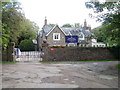
Monmouth Prep School, Dixton
A Haberdashers' School for children aged 3 to 7.
Image: © Jaggery
Taken: 5 Sep 2021
0.00 miles
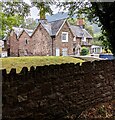
2
Crown depiction, Dixton
Showing 1952 - 2022 (the 70 year reign of Queen Elizabeth II),
the depiction is on a wall of Monmouth Prep School in November 2022.
Image: © Jaggery
Taken: 13 Nov 2022
0.01 miles
3
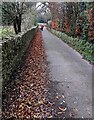
Fallen leaves, Dixton
Alongside the path from St Peter's churchyard to Dixton Lane on December 19th 2021.
Image: © Jaggery
Taken: 19 Dec 2021
0.02 miles
4

Daffodils in late winter, Dixton, Monmouth
Alongside a perimeter wall of Monmouth Prep School on February 18th 2024.
Image: © Jaggery
Taken: 18 Feb 2024
0.02 miles
5

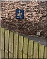
Become a Friend of Dixton Church, Monmouth
The notice is alongside the path from Dixton Lane to St Peter's churchyard in December 2021. It shows "We need your Time, Skills or Donations to help us maintain this beautiful church for all our futures".
Image: © Jaggery
Taken: 19 Dec 2021
0.02 miles
6
Welcome to Monmouth Prep School, Dixton
The Welcome faces the A40 at the edge of the prep school https://www.geograph.org.uk/photo/6963554 site at the NE end of Dixton Lane.
Image: © Jaggery
Taken: 5 Sep 2021
0.02 miles
7
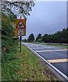
Warning sign - School / Ysgol, Dixton, Monmouth
English / Welsh sign alongside the A40 on the approach to the Dixton Lane junction.
Image: © Jaggery
Taken: 24 Oct 2021
0.02 miles
8
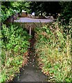
Path from the A40 to Dixton Lane, Monmouth
Ahead for St Peter's Church. https://www.geograph.org.uk/photo/3140881
Image: © Jaggery
Taken: 1 Aug 2021
0.02 miles
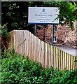
9

Wooden fence and gate, Dixton
Opposite the dead end of Dixton Lane, the gate gives walkers access to the A40.
Behind the camera for St Peter's Church on a bank of the River Wye.
Image: © Jaggery
Taken: 13 Nov 2022
0.02 miles
10
Entrance to Haberdashers' Agincourt School, Dixton
Located at the far end of Dixton Lane, http://www.geograph.org.uk/photo/2099793 which connects the school with the A40 and A466 at the NE edge of Monmouth.
The school is a co-educational pre-preparatory school for children aged 3 to 7.
Image: © Jaggery
Taken: 12 Sep 2010
0.03 miles