IMAGES TAKEN NEAR TO
Dixton Road, MONMOUTH, NP25 3PX
Introduction
This page details the photographs taken nearby to Dixton Road, NP25 3PX by members of the Geograph project.
The Geograph project started in 2005 with the aim of publishing, organising and preserving representative images for every square kilometre of Great Britain, Ireland and the Isle of Man.

There are currently over 7.5m images from over14,400 individuals and you can help contribute to the project by visiting https://www.geograph.org.uk
Image Map
Images are licensed for reuse under creativecommons.org/licenses/by-sa/2.0
Notes
- Clicking on the map will re-center to the selected point.
- The higher the marker number, the further away the image location is from the centre of the postcode.
Image Listing (751 Images Found)
Images are licensed for reuse under creativecommons.org/licenses/by-sa/2.0
Image
Details
Distance
1
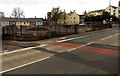
Dixton Road demolition site, Monmouth
In late October 2014, fencing encloses this site on the south side of Dixton Road near Monmouth Comprehensive School. A former clinic has been demolished, leaving piles of rubble.
Image: © Jaggery
Taken: 26 Oct 2014
0.00 miles
2

Two Howards of Monmouth removals vehicles in Dixton Road, Monmouth
Text on the side of the vehicles includes "LOW COST REMOVALS ANYWHERE IN THE UK".
Are these vehicles large vans or smallish lorries?
Image: © Jaggery
Taken: 26 Oct 2014
0.01 miles
4
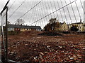
Demolition site rubble, Monmouth
Viewed from this http://www.geograph.org.uk/photo/4227844 path looking at the remains of a demolished former Dixton Road clinic.
Image: © Jaggery
Taken: 26 Oct 2014
0.01 miles
5
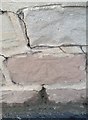
Ordnance Survey Cut Mark
This OS cut mark can be found on the wall NW side of Dixton Road. It marks a point 82.4ft above mean sea level.
Image: © Adrian Dust
Taken: 30 Jan 2019
0.01 miles
6
NEW
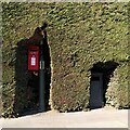
Hedge with cutaways, Dixton Road, Monmouth
One is for a letterbox, the other for a litter bin. The hedge is dense and coniferous and looks like leylandii.
Image: © A J Paxton
Taken: 13 Mar 2025
0.02 miles
7

Path between fences south of Dixton Road, Monmouth
Towards a street named Burgage. Monmouth Comprehensive School perimeter fence is on the left.
The fence on the right is at the edge of a demolished former clinic.
Image: © Jaggery
Taken: 26 Oct 2014
0.03 miles
8
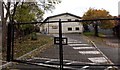
Entrance gate to the Phoenix Building, Monmouth
Viewed from a street named Burgage looking into Monmouth Comprehensive School.
The Phoenix Building is a two storey block of classrooms containing the ICT, Business Studies and History Departments.
Image: © Jaggery
Taken: 26 Oct 2014
0.03 miles
9
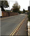
No parking at any time on Dixton Road, Monmouth
Double yellow lines on both sides of Dixton Road make parking
here illegal at any time. Viewed from the corner of Monk Street.
Image: © Jaggery
Taken: 26 Oct 2014
0.03 miles
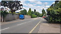
10
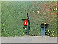
Hedge post box
A hedge on Dixton Road, Monmouth, closely clipped to accommodate a post box and litter bin.
Image: © Mike Parker
Taken: 4 Jul 2022
0.04 miles