IMAGES TAKEN NEAR TO
Monkswell Road, MONMOUTH, NP25 3PF
Introduction
This page details the photographs taken nearby to Monkswell Road, NP25 3PF by members of the Geograph project.
The Geograph project started in 2005 with the aim of publishing, organising and preserving representative images for every square kilometre of Great Britain, Ireland and the Isle of Man.

There are currently over 7.5m images from over14,400 individuals and you can help contribute to the project by visiting https://www.geograph.org.uk
Image Map
Images are licensed for reuse under creativecommons.org/licenses/by-sa/2.0
Notes
- Clicking on the map will re-center to the selected point.
- The higher the marker number, the further away the image location is from the centre of the postcode.
Image Listing (356 Images Found)
Images are licensed for reuse under creativecommons.org/licenses/by-sa/2.0
Image
Details
Distance
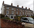
1
Monkswell Road, Monmouth
Long cul-de-sac on the east side of the A466 Hereford Road.
Image: © Jaggery
Taken: 26 Oct 2014
0.03 miles
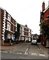
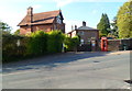
2
Row of houses, Monkswell Road, Monmouth
At the SE end of Monkswell Road, near Monkswell Close.
Image: © Jaggery
Taken: 26 Oct 2014
0.04 miles
3
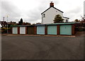
Six lockup garages in Monkswell Close, Monmouth
Between Monkswell Close on this side and Monkswell Road behind the garages.
Image: © Jaggery
Taken: 26 Oct 2014
0.04 miles
4
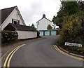
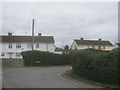
Monkswell Close, Monmouth
Looking towards lockup garages http://www.geograph.org.uk/photo/4227698 from the corner of Dixton Close.
Image: © Jaggery
Taken: 26 Oct 2014
0.04 miles
5
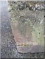
Ordnance Survey Cut Mark
This OS cut mark can be found on the wall at the junction of Monkswell Road & Monkswell Close. It marks a point 26.646m above mean sea level.
Image: © Adrian Dust
Taken: 30 Jan 2019
0.04 miles
6

Ordnance Survey Cut Mark
This OS cut mark can be found on Westfield House, Monk Street. It marks a point 29.307m above mean sea level.
Image: © Adrian Dust
Taken: 30 Jan 2019
0.05 miles
7
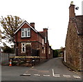
The Gardens, Monmouth
The Gardens is a road from Hereford Road to Dixton Close,
past the southern edge of Haberdashers' Monmouth School for Girls.
Image: © Jaggery
Taken: 26 Oct 2014
0.05 miles
8
Sharp corner in Dixton Close, Monmouth
Image: © Peter Robinson
Taken: 4 Apr 2015
0.06 miles
9
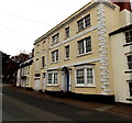
North Parade House, Monmouth
Late 18th century house viewed across the A466 Hereford Road.
Image: © Jaggery
Taken: 26 Oct 2014
0.06 miles
10
The Old Gaol, Monmouth
Viewed across Hereford Road (A466). This was formerly the site of Monmouth County Gaol.
A Monmouth Civic Society and Monmouth Town Council blue plaque http://www.geograph.org.uk/photo/2665381 records:
Monmouth County Gaol
Opened in 1790 to a design by John Howard, closed 1869. Demolished 1884, except Gatehouse, which was the site of public executions on its original flat roof until 1859. The Chartists were held here in 1840 during their trial in Shire Hall.
Image: © Jaggery
Taken: 22 Oct 2011
0.07 miles