IMAGES TAKEN NEAR TO
Priory Street, MONMOUTH, NP25 3NX
Introduction
This page details the photographs taken nearby to Priory Street, NP25 3NX by members of the Geograph project.
The Geograph project started in 2005 with the aim of publishing, organising and preserving representative images for every square kilometre of Great Britain, Ireland and the Isle of Man.

There are currently over 7.5m images from over14,400 individuals and you can help contribute to the project by visiting https://www.geograph.org.uk
Image Map
Images are licensed for reuse under creativecommons.org/licenses/by-sa/2.0
Notes
- Clicking on the map will re-center to the selected point.
- The higher the marker number, the further away the image location is from the centre of the postcode.
Image Listing (889 Images Found)
Images are licensed for reuse under creativecommons.org/licenses/by-sa/2.0
Image
Details
Distance
1
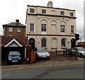
![Monmouth buildings [49]](https://s1.geograph.org.uk/geophotos/06/93/78/6937841_4801e7f9_120x120.jpg)
Monmouth buildings [49]
Set well back from the street, the Masonic Temple was built in 1797 as a theatre. It was converted into a Masonic Temple in 1837 and refronted in 1846. Constructed in a classical style of roughcast brick under a Welsh slate roof. The building suffered a fire in 2005. Listed, grade II, with details at: https://cadwpublic-api.azurewebsites.net/reports/listedbuilding/FullReport?lang=&id=2276
Monmouth is a market town at the confluence of the Rivers Monnow and Wye some 30 miles northeast of Cardiff. Although there is evidence of settlement in the Neolithic period, the town was established around the Norman castle which was the birthplace of King Henry V. The historic county town of Monmouthshire, the town is now a centre for Wye Valley tourism.
Image: © Michael Dibb
Taken: 28 May 2021
0.01 miles
2
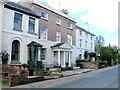
Kingsley House and Hendre House, Monmouth
The pair of neoclassical early Victorian (1839) semi-detached houses in Monk Street are near the corner of Priory Street. The three blind central windows are reminders of the actions often taken by householders to reduce their liability under the Window Tax, introduced in 1696 in the reign of King William III, repealed in 1851.
Image: © Jaggery
Taken: 26 Oct 2014
0.01 miles
3
![Monmouth houses [37]](https://s3.geograph.org.uk/geophotos/06/93/78/6937827_3d72a06b_120x120.jpg)
Monmouth houses [37]
Numbers 8 and 10 Monk Street are a pair of neo-classical semi-detached houses built in 1839. Constructed of stuccoed brick with a concealed roof. Listed, grade II, with details at: https://cadwpublic-api.azurewebsites.net/reports/listedbuilding/FullReport?lang=&id=85015
Monmouth is a market town at the confluence of the Rivers Monnow and Wye some 30 miles northeast of Cardiff. Although there is evidence of settlement in the Neolithic period, the town was established around the Norman castle which was the birthplace of King Henry V. The historic county town of Monmouthshire, the town is now a centre for Wye Valley tourism.
Image: © Michael Dibb
Taken: 28 May 2021
0.01 miles
4
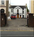
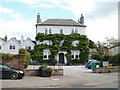
Masonic Hall, Monmouth
Set back nearly 30 metres (about 100 ft) from the west side of Monk Street.
Built as a theatre in 1797, converted into a Masonic Temple in 1837 by George Vaughan Maddox.
The frontage seen here dates from 1846, designed by the same architect.
Image: © Jaggery
Taken: 26 Oct 2014
0.01 miles
5
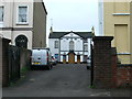
Masonic Lodge, Monmouth
On North Parade.
Image: © Eirian Evans
Taken: 2 Dec 2011
0.01 miles
6
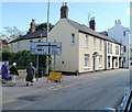
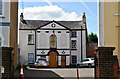
Monk Street houses, Monmouth
A short row of houses located adjacent to the crossroads of the A466 and B4293.
Image: © Jaggery
Taken: 12 Sep 2010
0.02 miles
7
North Parade houses, Monmouth
Houses on the west side of North Parade (A466).
Image: © Jaggery
Taken: 12 Sep 2010
0.02 miles
8
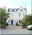
Monnow Bank House, Monmouth
House bordering the east bank of the River Monnow, on the west side of North Parade.
Image: © Jaggery
Taken: 12 Sep 2010
0.02 miles
9
Parade House Residential Home, Monmouth
3-storey 18th century building on the east side of North Parade. It is now used as a residential home.
Image: © Jaggery
Taken: 12 Sep 2010
0.02 miles
10
Freemasons Hall, Monmouth
Set back from Monk Street, the hall was built as a theatre in 1797 and converted to its present use by G.V. Maddox in 1837. He rebuilt the facade in 1846, since when there have been few changes.
Image: © Philip Pankhurst
Taken: 15 Jun 2017
0.02 miles