IMAGES TAKEN NEAR TO
Chaucer Way, MONMOUTH, NP25 3NR
Introduction
This page details the photographs taken nearby to Chaucer Way, NP25 3NR by members of the Geograph project.
The Geograph project started in 2005 with the aim of publishing, organising and preserving representative images for every square kilometre of Great Britain, Ireland and the Isle of Man.

There are currently over 7.5m images from over14,400 individuals and you can help contribute to the project by visiting https://www.geograph.org.uk
Image Map
Images are licensed for reuse under creativecommons.org/licenses/by-sa/2.0
Notes
- Clicking on the map will re-center to the selected point.
- The higher the marker number, the further away the image location is from the centre of the postcode.
Image Listing (23 Images Found)
Images are licensed for reuse under creativecommons.org/licenses/by-sa/2.0
Image
Details
Distance
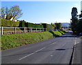
1
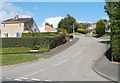
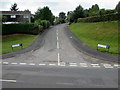
Chaucer Way, Osbaston
Chaucer Way climbs away from Osbaston Road.
Image: © Jaggery
Taken: 12 Sep 2010
0.07 miles
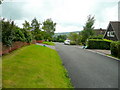
2
Osbaston : corner of Osbaston Road and Chaucer Way
Viewed across Osbaston Road.
Image: © Jaggery
Taken: 12 Sep 2010
0.07 miles
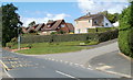
3
Prospect Road, Osbaston
Detached houses in the northern suburb of Monmouth, looking south.
Image: © Jonathan Billinger
Taken: 14 Jul 2009
0.10 miles
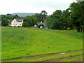
4
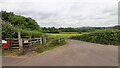
Footpath from Osbaston Road
Over one field to Forge Road and the Monnow.
Image: © Jonathan Billinger
Taken: 21 Jun 2021
0.12 miles
6
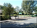
Pedestrian entrance to Osbaston Church in Wales School
Viewed across Osbaston Road. A gate in the railings gives pedestrians an entrance at the SE edge of the school. The main gate is about 70 metres away. http://www.geograph.org.uk/photo/2063668
Image: © Jaggery
Taken: 12 Sep 2010
0.18 miles
7
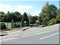
Main entrance to Osbaston Church in Wales School
Viewed across Osbaston Road.
Image: © Jaggery
Taken: 12 Sep 2010
0.19 miles
8
Elevated pavement, Hereford Road, Monmouth
There is a long stretch of pavement raised above road level on the east side of Hereford Road (A466). The section seen here is on the west side of houses in The Rickfield. The right turn is into Vine Acre. http://www.geograph.org.uk/photo/5403894
Image: © Jaggery
Taken: 22 Oct 2011
0.20 miles
9
Vine Acre, Monmouth
Cul-de-sac viewed across the A466 Hereford Road.
Image: © Jaggery
Taken: 21 Aug 2016
0.20 miles
10
View to the end of Forge Road
Looking east from beside Osbaston Weir.
A public footpath follows the field edge to the right.
Image: © Jonathan Billinger
Taken: 14 Jul 2009
0.20 miles