IMAGES TAKEN NEAR TO
Mayhill, MONMOUTH, NP25 3LX
Introduction
This page details the photographs taken nearby to NP25 3LX by members of the Geograph project.
The Geograph project started in 2005 with the aim of publishing, organising and preserving representative images for every square kilometre of Great Britain, Ireland and the Isle of Man.

There are currently over 7.5m images from over14,400 individuals and you can help contribute to the project by visiting https://www.geograph.org.uk
Image Map
Images are licensed for reuse under creativecommons.org/licenses/by-sa/2.0
Notes
- Clicking on the map will re-center to the selected point.
- The higher the marker number, the further away the image location is from the centre of the postcode.
Image Listing (161 Images Found)
Images are licensed for reuse under creativecommons.org/licenses/by-sa/2.0
Image
Details
Distance
1
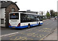
Sunday bus in Mayhill, Monmouth
The NAT (New Adventure Travel) single-decker is on the A4136 heading towards Monmouth Bus Station via Wye Bridge. It is the first bus of the day on route 69 from Chepstow, where scheduled departure time was 10.30am. Its route here was via St Arvans, Tintern, Llandogo, Redbrook and Wyesham.
Scheduled arrival at Monmouth Bus Station is 11.10. It is now 11.05, so it is on time.
Image: © Jaggery
Taken: 26 Apr 2015
0.01 miles
2
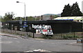
Topstak, Mayhill, Monmouth
Topstak Stoves, Kitchens & Renewables, Mayhill Industrial Estate, viewed across the A4136.
Image: © Jaggery
Taken: 26 Apr 2015
0.01 miles
3
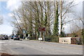
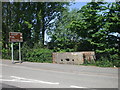
Pillbox at May Hill, Monmouth
This view looks north-west towards the Wye bridge and the town of Monmouth. The WW2 pillbox on the right (with three embrasures visible facing south-west) currently overlooks the roundabout at the junction of the A466 and A4136 and a new LIDL supermarket carpark. Originally, when constructed in 1940, it formed part of the defensive fortifications guarding the bridge and the main railway line (now disused).
Image: © Roger Davies
Taken: 23 Mar 2008
0.01 miles
4
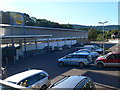
Lidl at Monmouth
Lidl is situated across the river from the centre of Monmouth, on the Chepstow road.
Image: © Eirian Evans
Taken: 25 Sep 2010
0.02 miles
5
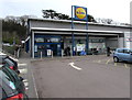
Entrance to Lidl Monmouth
Supermarket on the corner of the A466 Redbrook Road and the A4136, on the east side of the River Wye.
Image: © Jaggery
Taken: 1 Mar 2015
0.02 miles
6
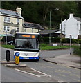
Bus from Wyesham in Mayhill, Monmouth
On route 69 from Chepstow, the NAT (New Adventure Travel) single-decker http://www.geograph.org.uk/photo/4450831
is on the corner of Wyesham Road and the A4136, heading towards Monmouth bus station.
Mayhill Hotel http://www.geograph.org.uk/photo/4450805 is in the background.
Image: © Jaggery
Taken: 26 Apr 2015
0.02 miles
7
Disused buildings in Mayhill, Monmouth
Up for sale but not looking very cared for.
Image: © Jeremy Bolwell
Taken: 19 Aug 2012
0.02 miles
8
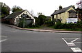
Two derelict buildings in Mayhill, Monmouth
Viewed across the A4136 in late April 2015.
The buildings looked similarly derelict in a June 2011 Google Earth Street View.
Image: © Jaggery
Taken: 26 Apr 2015
0.02 miles
9
Wartime pill-box, Monmouth
The pill-box guards the junction of the A466 and the A4136
Image: © John Lord
Taken: 24 May 2010
0.02 miles
10
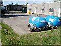
Two blue water bowsers, Mayhill, Monmouth
The bowsers are inside this http://www.geograph.org.uk/photo/3060898 Welsh Water site. A bowser is the usual name for this type of tanker used for fuelling aircraft, tanks, etc, or (as here) for supplying water. The notice on the bowser is
BOIL WATER BEFORE USE.
Image: © Jaggery
Taken: 2 May 2011
0.02 miles