IMAGES TAKEN NEAR TO
Wyesham, MONMOUTH, NP25 3JZ
Introduction
This page details the photographs taken nearby to NP25 3JZ by members of the Geograph project.
The Geograph project started in 2005 with the aim of publishing, organising and preserving representative images for every square kilometre of Great Britain, Ireland and the Isle of Man.

There are currently over 7.5m images from over14,400 individuals and you can help contribute to the project by visiting https://www.geograph.org.uk
Image Map
Images are licensed for reuse under creativecommons.org/licenses/by-sa/2.0
Notes
- Clicking on the map will re-center to the selected point.
- The higher the marker number, the further away the image location is from the centre of the postcode.
Image Listing (81 Images Found)
Images are licensed for reuse under creativecommons.org/licenses/by-sa/2.0
Image
Details
Distance
1
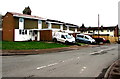
Chestnut Terrace, Wyesham
From the corner of Wyesham Road.
Image: © Jaggery
Taken: 26 Apr 2015
0.01 miles
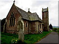
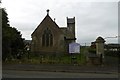
2
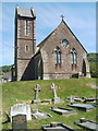
Tower, Church of St James, Wyesham
Viewed from the SW corner of the churchyard. The Church of England church was built in 1873.
Image: © Jaggery
Taken: 2 May 2011
0.02 miles
3
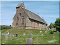
Church of St James, Wyesham, viewed from the south
The Church of England church, built in 1873, is in the centre of Wyesham, located between Wyesham Avenue and Wyesham Road.
Image: © Jaggery
Taken: 2 May 2011
0.02 miles
4
The Church of St James, Wyesham
Church of England, Diocese of Hereford, http://www.geograph.org.uk/photo/4448837 church built in 1873, located in the centre of Wyesham.
Image: © Jaggery
Taken: 2 May 2011
0.02 miles
5
Welsh church in the Church of England, Wyesham
Although the Church of St James is in Wyesham Monmouthshire (Wales), the church nameboard http://www.geograph.org.uk/photo/4448837
shows that it is in the Diocese of Hereford and thus part of the Church of England, not the Church in Wales.
Image: © Jaggery
Taken: 26 Apr 2015
0.03 miles
6
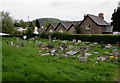
Small churchyard in Wyesham
Burial ground at the SW edge of the Church of St James. http://www.geograph.org.uk/photo/4448842
Image: © Jaggery
Taken: 26 Apr 2015
0.03 miles
7
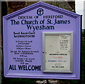
Church of England church board in Wyesham, Wales
The board is outside the Church of St James, Wyesham. http://www.geograph.org.uk/photo/2395494
Wyesham is a village in Monmouthshire, Wales, effectively a suburb of Monmouth.
I was expecting to see Diocese of Monmouth (Church in Wales) on this board, rather than Diocese of Hereford (Church of England). The Diocese of Hereford also has a few parishes in Powys, Wales.
Image: © Jaggery
Taken: 26 Apr 2015
0.03 miles
8
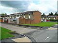
Chestnut Terrace, Wyesham
Affordable housing in Monmouth's suburb east of the Wye.
Image: © Jonathan Billinger
Taken: 15 Jul 2009
0.03 miles
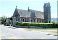
9
St James, Wyesham
Anglican church (Diocese of Hereford).
Image: © Richard Webb
Taken: 20 Oct 2016
0.03 miles
10
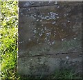
Ordnance Survey Cut Mark
This OS cut mark can be found on the NE face of St James Church. It marks a point 43.480m above mean sea level.
Image: © Adrian Dust
Taken: 30 Jan 2019
0.03 miles