IMAGES TAKEN NEAR TO
Wyesham Lane, MONMOUTH, NP25 3JU
Introduction
This page details the photographs taken nearby to Wyesham Lane, NP25 3JU by members of the Geograph project.
The Geograph project started in 2005 with the aim of publishing, organising and preserving representative images for every square kilometre of Great Britain, Ireland and the Isle of Man.

There are currently over 7.5m images from over14,400 individuals and you can help contribute to the project by visiting https://www.geograph.org.uk
Image Map
Images are licensed for reuse under creativecommons.org/licenses/by-sa/2.0
Notes
- Clicking on the map will re-center to the selected point.
- The higher the marker number, the further away the image location is from the centre of the postcode.
Image Listing (13 Images Found)
Images are licensed for reuse under creativecommons.org/licenses/by-sa/2.0
Image
Details
Distance
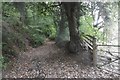
1
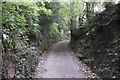
Wyesham Lane
Deeply sunken, and now the old trick of moving sideways to a parallel track is no longer available.
Image: © Richard Webb
Taken: 20 Oct 2016
0.03 miles
3
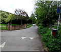
Wyesham Road speed bump, Wyesham
Wyesham Road here narrows to a lane ahead. The sign on the right shows that this is not a through route.
Image: © Jaggery
Taken: 26 Apr 2015
0.10 miles
4
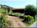
A Dutch barn, Wyesham Road, Wyesham
Viewed from the rural SE end of Wyesham Road.
Image: © Jaggery
Taken: 2 May 2011
0.14 miles
5
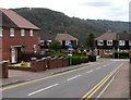
Woodland View, Wyesham
Houses on the south side of Wyesham Road.
Image: © Jaggery
Taken: 26 Apr 2015
0.18 miles
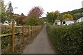
6
Tudor Road, Wyesham
Viewed across Wyesham Road.
Image: © Jaggery
Taken: 26 Apr 2015
0.19 miles
7
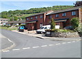
Tudor Road, Wyesham
Houses on the corner of Tudor Road, viewed across Wyesham Road.
Image: © Jaggery
Taken: 2 May 2011
0.19 miles
8
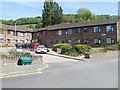
Hammett Court, Wyesham
Built in 1984, Hammett Court contains 31 rented flats, with from 1 to 3 bedrooms per flat. Residents, who must be aged at least 50, have access to a resident management staff and community alarm service.
Image: © Jaggery
Taken: 2 May 2011
0.19 miles
9
Wyesham Lane
Tarred lower down, but becomes a sunken green lane which climbs steeply - height gained which is all too quickly lost again.
Image: © Richard Webb
Taken: 20 Oct 2016
0.20 miles
10
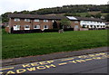
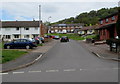
Two rows of houses, Wyesham Road, Wyesham
Viewed across the KEEP CLEAR zone around the entrance http://www.geograph.org.uk/photo/4448901 to Kymin View Primary School & Nursery.
Image: © Jaggery
Taken: 26 Apr 2015
0.21 miles