IMAGES TAKEN NEAR TO
Hereford Road, MONMOUTH, NP25 3HG
Introduction
This page details the photographs taken nearby to Hereford Road, NP25 3HG by members of the Geograph project.
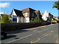
The Geograph project started in 2005 with the aim of publishing, organising and preserving representative images for every square kilometre of Great Britain, Ireland and the Isle of Man.

There are currently over 7.5m images from over14,400 individuals and you can help contribute to the project by visiting https://www.geograph.org.uk
Image Map
Images are licensed for reuse under creativecommons.org/licenses/by-sa/2.0
Notes
- Clicking on the map will re-center to the selected point.
- The higher the marker number, the further away the image location is from the centre of the postcode.
Image Listing (88 Images Found)
Images are licensed for reuse under creativecommons.org/licenses/by-sa/2.0
Image
Details
Distance
1
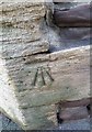
Ordnance Survey Cut Mark
This OS cut mark can be found on St Margaret's Lodge. It marks a point 44.116m above mean sea level.
Image: © Adrian Dust
Taken: 30 Jan 2019
0.01 miles
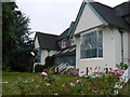
2
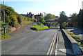
An entrance to Haberdashers' Monmouth School for Girls
The school occupies buildings on both sides of Hereford Road (A466), connected by the footbridge seen here. The independent school was established by the Worshipful Company of Haberdashers in 1892.
Image: © Jaggery
Taken: 22 Oct 2011
0.03 miles
3
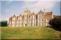
Haberdashers'?Monmouth School?for?Girls
A Girls Boarding School with an unusual War Memorial.
Image: © Stephen Elwyn RODDICK
Taken: 10 Sep 2002
0.03 miles
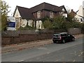
4
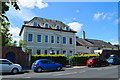
Chapel House, Monmouth
A stately mid-18th century house on the Hereford road out of town.
Image: © Philip Pankhurst
Taken: 15 Jun 2017
0.05 miles
5
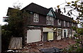
Derelict former hospital building, Monmouth
The north side of this http://www.geograph.org.uk/photo/4414072 building, viewed from a perimeter wall.
Image: © Jaggery
Taken: 26 Oct 2014
0.05 miles
6
Former Monmouth General Hospital
The building at 15 Hereford Road is part of the former Monmouth General Hospital, which closed down in 2006. An estate agent's sign shows "LAND ACQUIRED for a prestigious development of apartments and town houses".
Viewed in October 2014. Little has changed since this http://www.geograph.org.uk/photo/2665369 view taken 3 years earlier except
for the presence of Danger Keep Out notices now.
Image: © Jaggery
Taken: 26 Oct 2014
0.05 miles
7
Monmouth hospital
The old Monmouth hospital building, opened on this site in 1903, closed in 2006 about a year before this photograph was taken in and still, as far as I know, awaiting conversion to flats in 2014. The graffito which you can just make out the beginning of on the extreme right, reads "I don't wanna be a bunch of homes".
Image: © John Winder
Taken: 15 Jul 2007
0.06 miles
8
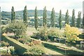
View to the Kymin
The Kymin in the distance overlooks Monmouth from the east. Just beyond the row of poplars is the playing fields of Haberdasher's School.
Image: © Jonathan Billinger
Taken: Unknown
0.06 miles
9
Former Monmouth General Hospital
The building at 15 Hereford Road is part of the former Monmouth General Hospital, which closed down in 2006. An estate agent's sign shows "LAND ACQUIRED for a prestigious development of apartments and town houses".
Image: © Jaggery
Taken: 22 Oct 2011
0.08 miles
10
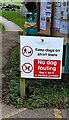
NEW
Keep dogs on short leads in Monmouth Cemetery
Text on the Monmouthshire County Council notice at
the southern entrance to the municipal cemetery also shows
No dog fouling. Bag it, bin it, in the bins provided.
Image: © Jaggery
Taken: 9 Mar 2025
0.08 miles