IMAGES TAKEN NEAR TO
Hereford Road, MONMOUTH, NP25 3GE
Introduction
This page details the photographs taken nearby to Hereford Road, NP25 3GE by members of the Geograph project.
The Geograph project started in 2005 with the aim of publishing, organising and preserving representative images for every square kilometre of Great Britain, Ireland and the Isle of Man.

There are currently over 7.5m images from over14,400 individuals and you can help contribute to the project by visiting https://www.geograph.org.uk
Image Map
Images are licensed for reuse under creativecommons.org/licenses/by-sa/2.0
Notes
- Clicking on the map will re-center to the selected point.
- The higher the marker number, the further away the image location is from the centre of the postcode.
Image Listing (66 Images Found)
Images are licensed for reuse under creativecommons.org/licenses/by-sa/2.0
Image
Details
Distance
1
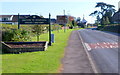
Northern boundary of Monmouth
The A466 reaches Monmouth, population 8,877 (2001 Census).
Among the attractions shown on the brown sign are
Ancient bridge. http://www.geograph.org.uk/photo/2250659
Castle. http://www.geograph.org.uk/photo/1373622
Nelson Museum. http://www.geograph.org.uk/photo/649350
Image: © Jaggery
Taken: 22 Oct 2011
0.02 miles
2
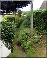
Narrow public footpath towards Manson's Lane, Monmouth
From the A466 Hereford Road.
Image: © Jaggery
Taken: 21 Aug 2016
0.03 miles
3
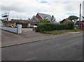
House construction, Hereford Road, Monmouth
In August 2016, a house is being built (or rebuilt).
An October 2011 Google Earth Street View shows a bungalow here.
Image: © Jaggery
Taken: 21 Aug 2016
0.03 miles
4
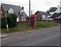
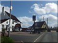
Red phonebox near the Royal Oak pub, Monmouth
The phonebox alongside the A466 is between a wonky bus stop pole and the Royal Oak pub. http://www.geograph.org.uk/photo/2664452
Image: © Jaggery
Taken: 21 Aug 2016
0.04 miles
5
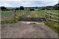
Grid across a farm track in the north of Monmouth
On the northwest side of Hereford Road.
Image: © Jaggery
Taken: 21 Aug 2016
0.04 miles
6
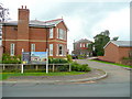
The Mount, Hereford Road, Monmouth
A development of larger homes opposite the Royal Oak pub.
Image: © Jonathan Billinger
Taken: 14 Jul 2009
0.04 miles
7
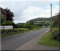
Road from Monmouth towards Hereford
North along the A466 Hereford Road in the north of Monmouth.
Image: © Jaggery
Taken: 21 Aug 2016
0.05 miles
8
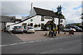
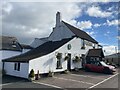
Royal Oak, Monmouth
The Royal Oak on the A466 is situated right on the easting OS grid line between two squares.
Image: © Philip Halling
Taken: 21 Sep 2013
0.05 miles
9
The Royal Oak
Hereford Road, Monmouth.
Image: © John H Darch
Taken: 22 Oct 2021
0.06 miles
10
The car park and inn sign of the Royal Oak inn
Image: © David Smith
Taken: 16 Apr 2013
0.06 miles