IMAGES TAKEN NEAR TO
Whitecross Street, MONMOUTH, NP25 3DT
Introduction
This page details the photographs taken nearby to Whitecross Street, NP25 3DT by members of the Geograph project.
The Geograph project started in 2005 with the aim of publishing, organising and preserving representative images for every square kilometre of Great Britain, Ireland and the Isle of Man.

There are currently over 7.5m images from over14,400 individuals and you can help contribute to the project by visiting https://www.geograph.org.uk
Image Map
Images are licensed for reuse under creativecommons.org/licenses/by-sa/2.0
Notes
- Clicking on the map will re-center to the selected point.
- The higher the marker number, the further away the image location is from the centre of the postcode.
Image Listing (931 Images Found)
Images are licensed for reuse under creativecommons.org/licenses/by-sa/2.0
Image
Details
Distance
1
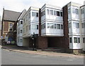
Pitmans Court, Monmouth
Flats on the corner of Monk Street and Whitecross Street.
Image: © Jaggery
Taken: 10 Jun 2018
0.01 miles
2
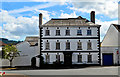
Whitecross House, Monmouth
Splendid 3-storey mid-eighteenth century town house at the end of Whitecross Street. Built around 1710, it was for a time the Portcullis Inn.
Image: © Philip Pankhurst
Taken: 15 Jun 2017
0.01 miles
3
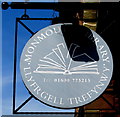
Monmouth Library name sign, Whitecross Street, Monmouth
The sign hanging from a wall bracket here https://www.geograph.org.uk/photo/5810824 shows that Monmouth Library is Llyfrgell Trefywny in Welsh.
Image: © Jaggery
Taken: 10 Jun 2018
0.01 miles
4
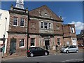
Monmouth library
Housed in the Rolls Hall Image
Image: © David Smith
Taken: 16 Apr 2013
0.02 miles
5
![Monmouth buildings [48]](https://s3.geograph.org.uk/geophotos/06/93/77/6937751_f09043f7_120x120.jpg)
Monmouth buildings [48]
Rolls Hall was built in 1887 as a general purpose hall, a gift to the town from J A Rolls, Lord Llangattock, to celebrate the golden jubilee of Queen Victoria. It was converted to be Monmouth Public Library in 1992. In a Jacobean style, it is constructed of squared sandstone rubble with ashlar dressings under a Welsh slate roof. Most original internal features remain. Listed, grade II, with details at: https://cadwpublic-api.azurewebsites.net/reports/listedbuilding/FullReport?lang=&id=85213
Monmouth is a market town at the confluence of the Rivers Monnow and Wye some 30 miles northeast of Cardiff. Although there is evidence of settlement in the Neolithic period, the town was established around the Norman castle which was the birthplace of King Henry V. The historic county town of Monmouthshire, the town is now a centre for Wye Valley tourism.
Image: © Michael Dibb
Taken: 4 Jun 2021
0.02 miles
6
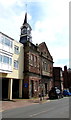
Beaver Framing Ltd, Monmouth
Picture framing business at 1 Monk Street in Monmouth town centre.
The Victorian inscription https://www.geograph.org.uk/photo/6138838 on the wall records that the building was a free institute for working men.
Image: © Jaggery
Taken: 10 Jun 2018
0.02 miles
7
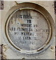
Inscription dated 1868 on the wall of 1 Monk Street, Monmouth
On the wall here https://www.geograph.org.uk/photo/6138832 the inscription is THIS FREE INSTITUTE FOR WORKING MEN WAS FOUNDED AND ENDOWED BY MRS MATILDA JONES OF ANCRE HILL AD 1868.
Image: © Jaggery
Taken: 10 Jun 2018
0.02 miles
8
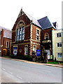
Monmouth Library, Rolls Hall, Whitecross Street, Monmouth
Monmouth Library is in the Rolls Hall which was given to the people of Monmouth for use as a lecture hall and theatre by the Rolls family in 1887, to commemorate the golden jubilee of the accession of Queen Victoria. After refurbishment, it reopened as Monmouth Library in 1992. Grade II listed in 2005.
Image: © Jaggery
Taken: 10 Jun 2018
0.02 miles
9
North side of Whitecross Street, Monmouth
Nearest the camera are Pitmans Court flats and Monmouth Library.
Image: © Jaggery
Taken: 10 Jun 2018
0.02 miles
10
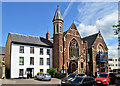
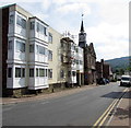
The Baptist Church, Monmouth
The Georgian house to the left seems umbilically attached to the church, which was designed by Benjamin Lawrence of Newport in 1906-7 in a free Gothic style. Lawrence also designed the (former) Working Men's Free Institute to the right of the church. This dates from 1867-8.
Image: © Philip Pankhurst
Taken: 15 Jun 2017
0.02 miles