IMAGES TAKEN NEAR TO
Whitecross Street, MONMOUTH, NP25 3BY
Introduction
This page details the photographs taken nearby to Whitecross Street, NP25 3BY by members of the Geograph project.
The Geograph project started in 2005 with the aim of publishing, organising and preserving representative images for every square kilometre of Great Britain, Ireland and the Isle of Man.

There are currently over 7.5m images from over14,400 individuals and you can help contribute to the project by visiting https://www.geograph.org.uk
Image Map
Images are licensed for reuse under creativecommons.org/licenses/by-sa/2.0
Notes
- Clicking on the map will re-center to the selected point.
- The higher the marker number, the further away the image location is from the centre of the postcode.
Image Listing (955 Images Found)
Images are licensed for reuse under creativecommons.org/licenses/by-sa/2.0
Image
Details
Distance
1
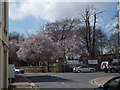
Blossom in St Mary's churchyard, Monmouth
Image: © David Smith
Taken: 16 Apr 2013
0.01 miles
2
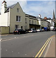
Whitecross Street, Monmouth
West along Whitecross Street towards Monmouth town centre.
The spire of St Mary's Church is in the background.
Image: © Jaggery
Taken: 10 Jun 2018
0.01 miles
3
![Monmouth houses [33]](https://s1.geograph.org.uk/geophotos/06/93/77/6937761_dfcc7593_120x120.jpg)
Monmouth houses [33]
Whitecross House, number 17 Whitecross Street, was built circa 1710 with early 19th century internal alterations. The building was The Portcullis Inn, possibly circa 1740 to circa 1820. Constructed of rendered and painted brick under a Welsh slate roof. Internal features and fittings from the early 18th and the early 19th centuries remain. Listed, grade II, with details at: https://cadwpublic-api.azurewebsites.net/reports/listedbuilding/FullReport?lang=&id=2362
Monmouth is a market town at the confluence of the Rivers Monnow and Wye some 30 miles northeast of Cardiff. Although there is evidence of settlement in the Neolithic period, the town was established around the Norman castle which was the birthplace of King Henry V. The historic county town of Monmouthshire, the town is now a centre for Wye Valley tourism.
Image: © Michael Dibb
Taken: 28 May 2021
0.01 miles
4
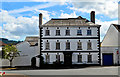
Whitecross House, Monmouth
Splendid 3-storey mid-eighteenth century town house at the end of Whitecross Street. Built around 1710, it was for a time the Portcullis Inn.
Image: © Philip Pankhurst
Taken: 15 Jun 2017
0.01 miles
5
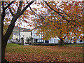
Along Whitecross Street
From a very autumnal churchyard where the trees are mainly beeches.
Image: © Pauline E
Taken: 26 Oct 2009
0.01 miles
6
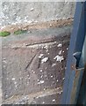
Ordnance Survey Cut Mark
This OS cut mark can be found on the wall of St Mary's Church Yard, Monk Street. It marks a point 24.664m above mean sea level.
Image: © Adrian Dust
Taken: 30 Jan 2019
0.01 miles
7
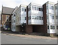
Pitmans Court, Monmouth
Flats on the corner of Monk Street and Whitecross Street.
Image: © Jaggery
Taken: 10 Jun 2018
0.01 miles
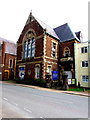
8

Grade II listed Monmouth Conservative Club
Located in Priory House, Whitecross Street, viewed from St Mary's churchyard.
The building probably has 18th century origins, much altered in the 19th century. Grade II listed in 1974.
Image: © Jaggery
Taken: 17 Jul 2016
0.02 miles
9
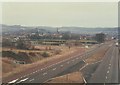
Monmouth & the A40 in 1985
The road sign on the left hand side of the A40 is directing traffic towards Treleck B4293 and (Rockfield B4233)
Image: © John Baker
Taken: 14 Mar 1985
0.02 miles
10
Beaver Framing Ltd, Monmouth
Picture framing business at 1 Monk Street in Monmouth town centre.
The Victorian inscription https://www.geograph.org.uk/photo/6138838 on the wall records that the building was a free institute for working men.
Image: © Jaggery
Taken: 10 Jun 2018
0.02 miles