IMAGES TAKEN NEAR TO
Forge Road, MONMOUTH, NP25 3AY
Introduction
This page details the photographs taken nearby to Forge Road, NP25 3AY by members of the Geograph project.
The Geograph project started in 2005 with the aim of publishing, organising and preserving representative images for every square kilometre of Great Britain, Ireland and the Isle of Man.

There are currently over 7.5m images from over14,400 individuals and you can help contribute to the project by visiting https://www.geograph.org.uk
Image Map
Images are licensed for reuse under creativecommons.org/licenses/by-sa/2.0
Notes
- Clicking on the map will re-center to the selected point.
- The higher the marker number, the further away the image location is from the centre of the postcode.
Image Listing (27 Images Found)
Images are licensed for reuse under creativecommons.org/licenses/by-sa/2.0
Image
Details
Distance
1
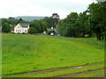
View to the end of Forge Road
Looking east from beside Osbaston Weir.
A public footpath follows the field edge to the right.
Image: © Jonathan Billinger
Taken: 14 Jul 2009
0.04 miles
3
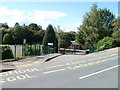
Main entrance to Osbaston Church in Wales School
Viewed across Osbaston Road.
Image: © Jaggery
Taken: 12 Sep 2010
0.08 miles
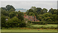
4
Monmouth New Hydro Scheme
This exciting New Hydro Scheme is the brainchild of a prominent local businessman. It is constructed on the site of the Old Monmouth Hydro Station. The original Monmouth Hydro Station commenced operations on 10th June 1899. In 1930 Monmouth Corporation sold the station to a subsidiary of the General Electric Company, which continued to operate it up until 1948. It finally closed down in 1953. The old plant comprised 3 35hp turbines made by Gilbert Gilkes & Co,together with standby steam engines and also a 100hp Ransoms,Sims & Jeffreys of Ipswich steam engine driving a 60kW generator. In 1922 the site was extended and larger turbines fitted. The new Hydro scheme works on the Archimedes Screw Principle and uses water from the River Monnow. The head of water is only 3.4 metres. Each "Screw" produces 75 kilowatts of power and turns at only 20 RPM. The new scheme commenced operations in February 2009. There are believed to be only two other similar schemes in the UK.
Image: © RAY JONES
Taken: 20 Mar 2009
0.11 miles
5
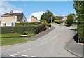
Chaucer Way, Osbaston
Chaucer Way climbs away from Osbaston Road.
Image: © Jaggery
Taken: 12 Sep 2010
0.11 miles
6
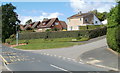
Osbaston : corner of Osbaston Road and Chaucer Way
Viewed across Osbaston Road.
Image: © Jaggery
Taken: 12 Sep 2010
0.11 miles
7
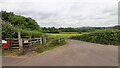
Footpath from Osbaston Road
Over one field to Forge Road and the Monnow.
Image: © Jonathan Billinger
Taken: 21 Jun 2021
0.13 miles
8
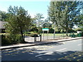
Pedestrian entrance to Osbaston Church in Wales School
Viewed across Osbaston Road. A gate in the railings gives pedestrians an entrance at the SE edge of the school. The main gate is about 70 metres away. http://www.geograph.org.uk/photo/2063668
Image: © Jaggery
Taken: 12 Sep 2010
0.14 miles
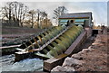
9
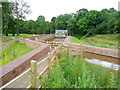
New fish pass at Osbaston Weir
Recently completed, this construction allows salmon to enter the Monnow system by negotiating the weir built 90 years ago.
Image: © Jonathan Billinger
Taken: 14 Jul 2009
0.14 miles
10
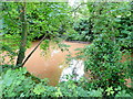
River Monnow
Adjacent to Forge Road.
The water looks like weak cocoa after recent rains.
Image: © Jonathan Billinger
Taken: 14 Jul 2009
0.14 miles