IMAGES TAKEN NEAR TO
Osbaston Road, MONMOUTH, NP25 3AX
Introduction
This page details the photographs taken nearby to Osbaston Road, NP25 3AX by members of the Geograph project.
The Geograph project started in 2005 with the aim of publishing, organising and preserving representative images for every square kilometre of Great Britain, Ireland and the Isle of Man.

There are currently over 7.5m images from over14,400 individuals and you can help contribute to the project by visiting https://www.geograph.org.uk
Image Map
Images are licensed for reuse under creativecommons.org/licenses/by-sa/2.0
Notes
- Clicking on the map will re-center to the selected point.
- The higher the marker number, the further away the image location is from the centre of the postcode.
Image Listing (64 Images Found)
Images are licensed for reuse under creativecommons.org/licenses/by-sa/2.0
Image
Details
Distance
1

Remains of an old weir or mill race
The OS map identifies this as a weir, though it appears more likely to be the remains of a mill race.
Image: © Philip Halling
Taken: 22 Jan 2006
0.02 miles
2
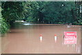
Floods at Osbaston Road
The River Monnow rises rapidly in periods of heavy rain and occasionally bursts it banks across Osbaston Road.
Image: © Matthew Lewis
Taken: 6 Sep 2008
0.02 miles
3

Balloon flight takes off from Vauxhall Field
Image: © Colin Pyle
Taken: 6 May 2012
0.07 miles
4
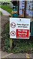
NEW
Keep dogs on short leads in Monmouth Cemetery
Text on the Monmouthshire County Council notice at
the southern entrance to the municipal cemetery also shows
No dog fouling. Bag it, bin it, in the bins provided.
Image: © Jaggery
Taken: 9 Mar 2025
0.07 miles
5

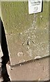
Ordnance Survey Cut Mark
The remains of this OS cut mark can be found on the front of the Mortuary Chapel. It marks a point 28.575m above mean sea level.
Image: © Adrian Dust
Taken: 30 Jan 2019
0.07 miles
6
Ordnance Survey Cut Mark
This OS cut mark can be found on the cemetery gatepost. It marks a point 19.549m above mean sea level.
Image: © Adrian Dust
Taken: 30 Jan 2019
0.08 miles
7
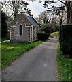
NEW
North side of the former chapel in Monmouth Cemetery
The back of the building dating from 1851 at the southern edge of the municipal cemetery.
Image: © Jaggery
Taken: 9 Mar 2025
0.08 miles
8

Bridge over the River Monnow
This was erected by the Royal Engineers, who have a camp on Vauxhall Fields, in 1931 as a replacement for an earlier structure. It's an Inglis bridge, so named after its inventor, Sir Charles Edward Inglis, who designed it to be portable, lightweight and easily erectable by a single army unit in the space of an afternoon. This is apparently a Mark II version of the design.
Image: © John Winder
Taken: 3 Feb 2009
0.09 miles
9

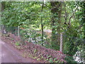
NEW
Path into Monmouth Cemetery
Ahead for the lowest part of the municipal cemetery,
most of which is on a hillside.
The former Chapel of Rest https://www.geograph.org.uk/photo/7992239 is on left.
Image: © Jaggery
Taken: 9 Mar 2025
0.09 miles
10
High Water Mark
It is mid-summer and the River Monnow, visible beyond the fence, is about 5 metres below the road level. After heavy prolonged rain, the river rises dramatically and debris from a previous rushing torrent can be seen forming a watermark on this chain link fence.
Image: © Marion Phillips
Taken: 30 Jun 2009
0.10 miles