IMAGES TAKEN NEAR TO
Cwrt William Jones, MONMOUTH, NP25 3AE
Introduction
This page details the photographs taken nearby to Cwrt William Jones, NP25 3AE by members of the Geograph project.
The Geograph project started in 2005 with the aim of publishing, organising and preserving representative images for every square kilometre of Great Britain, Ireland and the Isle of Man.

There are currently over 7.5m images from over14,400 individuals and you can help contribute to the project by visiting https://www.geograph.org.uk
Image Map
Images are licensed for reuse under creativecommons.org/licenses/by-sa/2.0
Notes
- Clicking on the map will re-center to the selected point.
- The higher the marker number, the further away the image location is from the centre of the postcode.
Image Listing (883 Images Found)
Images are licensed for reuse under creativecommons.org/licenses/by-sa/2.0
Image
Details
Distance
2
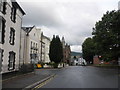
Citizens Advice Bureau, Monmouth
Set back from the north side of Whitecross Street near Attik Youth Centre. https://www.geograph.org.uk/photo/5808835
The sign on the left shows that citizens advice is cyngor ar bopeth in Welsh.
Image: © Jaggery
Taken: 10 Jun 2018
0.02 miles
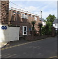
4
Whitecross Street
Monmouth's Citizen's Advice Bureau and a gated courtyard with dedicated keypad and entry for bikes and pushchairs.
Image: © Richard Webb
Taken: 20 Oct 2014
0.02 miles
5
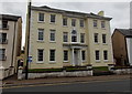
Elegant Georgian house in Monk Street, Monmouth
Built in 1737 during the reign of King George II, the 3-storey Royal George House
has Corinthian pillars at the entrance. The building has been divided into flats.
Image: © Jaggery
Taken: 26 Oct 2014
0.02 miles
6
![Monmouth houses [34]](https://s0.geograph.org.uk/geophotos/06/93/78/6937800_798b4744_120x120.jpg)
Monmouth houses [34]
Number 3 Monk Street was built in the early 18th century and the fenestration was altered in the early 19th century. The house was altered in the early and late 20th century. The house has been the Manse for the adjoining Baptist chapel since 1907. An adjoining similar house was demolished in 1906 so that the chapel could be built. Constructed of stuccoed brick under a Welsh slate roof. Listed, grade II, with details at: https://cadwpublic-api.azurewebsites.net/reports/listedbuilding/FullReport?lang=&id=2281
Monmouth is a market town at the confluence of the Rivers Monnow and Wye some 30 miles northeast of Cardiff. Although there is evidence of settlement in the Neolithic period, the town was established around the Norman castle which was the birthplace of King Henry V. The historic county town of Monmouthshire, the town is now a centre for Wye Valley tourism.
Image: © Michael Dibb
Taken: 28 May 2021
0.02 miles
7
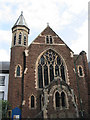
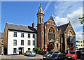
Monmouth Baptist Church
Located in Monk Street, Monmouth.
Image: © Alan Hughes
Taken: 20 Sep 2021
0.03 miles
8
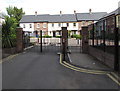
Cwrt William Jones entrance gates, Monmouth
Located 60 metres north of Whitecross Street.
The double gates are for motor vehicles only.
The small gate on the right is for walkers and cyclists.
Image: © Jaggery
Taken: 10 Jun 2018
0.03 miles
9
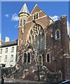
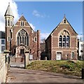
The Baptist Church, Monmouth
The Georgian house to the left seems umbilically attached to the church, which was designed by Benjamin Lawrence of Newport in 1906-7 in a free Gothic style. Lawrence also designed the (former) Working Men's Free Institute to the right of the church. This dates from 1867-8.
Image: © Philip Pankhurst
Taken: 15 Jun 2017
0.03 miles
10
NEW
A Victorian pair, Monk Street, Monmouth
Victorian and Edwardian, actually. On the right is the Working Men's Institute of 1868, looking shabby and disused; on the left, Monmouth Baptist Church of 1907, still in use by a Baptist congregation. Both are by Benjamin Lawrence of Newport. See Wikipedia https://en.m.wikipedia.org/wiki/1_Monk_Street,_Monmouth https://en.m.wikipedia.org/wiki/Monmouth_Baptist_Church .
The Institute bears the inscription
THIS FREE INSTITUTE FOR WORKING MEN WAS FOUNDED AND ENDOWED BY MRS MATILDA JONES OF ANGRE HILL AD 1868
Image: © A J Paxton
Taken: 13 Mar 2025
0.03 miles