IMAGES TAKEN NEAR TO
Greenfield Street, NEW TREDEGAR, NP24 6LG
Introduction
This page details the photographs taken nearby to Greenfield Street, NP24 6LG by members of the Geograph project.
The Geograph project started in 2005 with the aim of publishing, organising and preserving representative images for every square kilometre of Great Britain, Ireland and the Isle of Man.

There are currently over 7.5m images from over14,400 individuals and you can help contribute to the project by visiting https://www.geograph.org.uk
Image Map
Images are licensed for reuse under creativecommons.org/licenses/by-sa/2.0
Notes
- Clicking on the map will re-center to the selected point.
- The higher the marker number, the further away the image location is from the centre of the postcode.
Image Listing (245 Images Found)
Images are licensed for reuse under creativecommons.org/licenses/by-sa/2.0
Image
Details
Distance
1
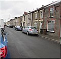
On-street parking, Greenfield Street, New Tredegar
Dead-end Greenfield Street is northwest of Commercial Street.
Image: © Jaggery
Taken: 17 Jun 2019
0.01 miles
2
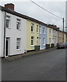
Pastel colours in New Tredegar
Houses alongside Greenfield Street.
Image: © Jaggery
Taken: 17 Jun 2019
0.02 miles
3
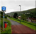
Combined footpath and cycleway, New Tredegar
Powell's Terrace https://www.geograph.org.uk/photo/6464486 is behind the camera.
Image: © Jaggery
Taken: 17 Jun 2019
0.03 miles
4
Red postbox in a Greenfield Street wall, New Tredegar
The GR https://www.geograph.org.uk/photo/6185612 on the box dates it to the reign of King George V (1910-1936).
Image: © Jaggery
Taken: 17 Jun 2019
0.03 miles
5
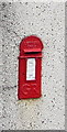
King George V postbox in a Greenfield Street wall, New Tredegar
Located here. https://www.geograph.org.uk/photo/6185607
The GR on the box is short for Georgius Rex,
Latin for King George, in this case King George V
who reigned from May 1910-January 1936
Image: © Jaggery
Taken: 17 Jun 2019
0.03 miles
6
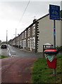
Bilingual end of cycle route sign, New Tredegar
Emglish/Welsh sign on the approach to Powell's Terrace.
Image: © Jaggery
Taken: 17 Jun 2019
0.04 miles
7
Electricity substation, Greenfield Street, New Tredegar
The Western Power Distribution electricity substation is inside a fenced enclosure.
Its identifier is POWELLS TCE NEW TREDEGAR S/S 552438
Image: © Jaggery
Taken: 17 Jun 2019
0.04 miles
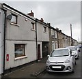
8
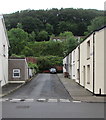
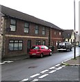
Eastern end of Chapel Street, New Tredegar
In the foreground, Commercial Street is on the right, Greenfield Street on the left.
Image: © Jaggery
Taken: 17 Jun 2019
0.04 miles
9
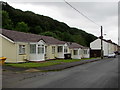
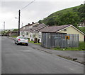
Row of bungalows, Greenfield Street, New Tredegar
Derived from a Hindi word meaning in the style of Bengal, bungalow was originally used in English for a lightly-built house, with a veranda and one storey. In current UK usage it is a convenient word for any one-storey dwelling.
Image: © Jaggery
Taken: 17 Jun 2019
0.04 miles
10
Commercial Street towards Greenfield Street, New Tredegar
Viewed from the corner of Ruperra Street looking to the NNW.
Image: © Jaggery
Taken: 17 Jun 2019
0.05 miles