IMAGES TAKEN NEAR TO
Railway Terrace, NEW TREDEGAR, NP24 6EY
Introduction
This page details the photographs taken nearby to Railway Terrace, NP24 6EY by members of the Geograph project.
The Geograph project started in 2005 with the aim of publishing, organising and preserving representative images for every square kilometre of Great Britain, Ireland and the Isle of Man.

There are currently over 7.5m images from over14,400 individuals and you can help contribute to the project by visiting https://www.geograph.org.uk
Image Map
Images are licensed for reuse under creativecommons.org/licenses/by-sa/2.0
Notes
- Clicking on the map will re-center to the selected point.
- The higher the marker number, the further away the image location is from the centre of the postcode.
Image Listing (195 Images Found)
Images are licensed for reuse under creativecommons.org/licenses/by-sa/2.0
Image
Details
Distance
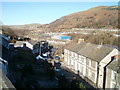
2
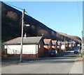
Bungalows, School Street, Tir-phil, New Tredegar
Viewed from opposite the community hall.
Image: © Jaggery
Taken: 20 Jan 2011
0.05 miles
4
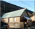
Chapel in School Street, Tirphil
Located opposite the Railway Terrace junction. Tirphil Community Hall is at the right edge of the view.
Image: © Jaggery
Taken: 20 Jan 2011
0.05 miles
5
Birchgrove, New Tredegar
Dead-end street on a bank of the Rhymney River.
Image: © Jaggery
Taken: 17 Jun 2019
0.06 miles
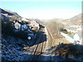
6
Tir-Phil railway station
Opened in 1858 by the Rhymney Railway on its line from Cardiff to Rhymney. View north west towards the former goods shed, hidden amongst other buildings.
Image: © Nigel Thompson
Taken: 18 Aug 2012
0.07 miles
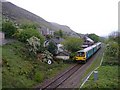
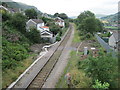
7
Railway NW of Tir-Phil railway station, New Tredegar
Viewed from the road bridge adjacent to the railway station. http://www.geograph.org.uk/photo/2243473 The single track Rhymney Line route heads towards Pontlottyn. While much of the area is bathed in bright January sunshine, overnight hoar frost remains on grass on the area in shade at the lower left corner of the view.
Image: © Jaggery
Taken: 20 Jan 2011
0.07 miles
8
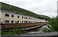
Riverside houses, Birchgrove, New Tredegar
Alongside the Rhymney River.
Image: © Jaggery
Taken: 17 Jun 2019
0.07 miles
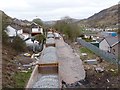
9
Sunnybank on a sunny day, Tir-Phil, New Tredegar
The view along a street named Sunnybank from the bridge carrying the A4049 above the Rhymney Line railway http://www.geograph.org.uk/photo/2274694 (part of the Valley Lines network).
Image: © Jaggery
Taken: 20 Jan 2011
0.08 miles
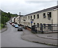
10
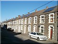
Solar panels, Railway Terrace, Tir-Phil
Viewed from near the corner of School Street. None of the solar panels, seen here in January 2011, were in a Google street view taken a few years earlier.
Image: © Jaggery
Taken: 20 Jan 2011
0.08 miles