IMAGES TAKEN NEAR TO
Elliot Street, NEW TREDEGAR, NP24 6DR
Introduction
This page details the photographs taken nearby to Elliot Street, NP24 6DR by members of the Geograph project.
The Geograph project started in 2005 with the aim of publishing, organising and preserving representative images for every square kilometre of Great Britain, Ireland and the Isle of Man.

There are currently over 7.5m images from over14,400 individuals and you can help contribute to the project by visiting https://www.geograph.org.uk
Image Map
Images are licensed for reuse under creativecommons.org/licenses/by-sa/2.0
Notes
- Clicking on the map will re-center to the selected point.
- The higher the marker number, the further away the image location is from the centre of the postcode.
Image Listing (158 Images Found)
Images are licensed for reuse under creativecommons.org/licenses/by-sa/2.0
Image
Details
Distance
1
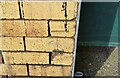
Ordnance Survey Cut Mark
This OS cut mark can be found on the Post Office, Tanlan Square. It marks a point 219.551m above mean sea level.
Image: © Adrian Dust
Taken: 12 Feb 2021
0.02 miles
2
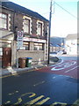
Side view of Cwmsyfiog Ex-Servicemen's Club and Institute
The club's name is on the side of the premises, but not on the front. http://www.geograph.org.uk/photo/2278481
Viewed across Queen's Road.
Image: © Jaggery
Taken: 20 Jan 2011
0.03 miles
3
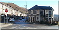
Cwmsyfiog Ex-Servicemen's Club and Institute
Located on the corner of Queen's Road and Elliot Street, New Tredegar. The club's name is shown on the side of the building http://www.geograph.org.uk/photo/2278487 facing the houses.
Image: © Jaggery
Taken: 20 Jan 2011
0.03 miles
4
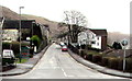
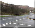
Elliot Street, New Tredegar
Viewed across a mini-roundabout at the White Rose Way junction in the Elliot's Town area of New Tredegar.
Image: © Jaggery
Taken: 23 Jan 2016
0.05 miles
5
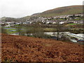
Towards New Tredegar from Brithdir
Looking towards the Elliot's Town area of New Tredegar from the northwest edge of Brithdir.
Image: © Jaggery
Taken: 23 Jan 2016
0.05 miles
6
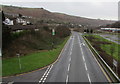
A4049 from New Tredegar towards Cwmsyfiog
This part of the A4049 is on a bank of the Rhymney River.
Image: © Jaggery
Taken: 23 Jan 2016
0.06 miles
7
Steps up from Queen's Road, New Tredegar
From a bend on Queen's Road, steps lead up to Alexandra Road and Brynteg Terrace.
Image: © Jaggery
Taken: 20 Jan 2011
0.06 miles
8
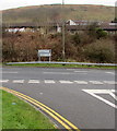
A4049 directions signs, New Tredegar
Facing the New Tredegar Business Park access road.
Left for Rhymney (Rhymni in Welsh) or right for Blackwood (Coed Duon in Welsh).
Image: © Jaggery
Taken: 23 Jan 2016
0.08 miles
9
A4049 descends away from New Tredegar
Viewed from this http://www.geograph.org.uk/photo/5135671 footbridge.
The buildings on the right are in New Tredegar Business Park.
Image: © Jaggery
Taken: 23 Jan 2016
0.08 miles
10
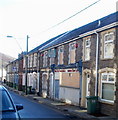
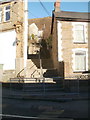
Derelict Bonar Law Constitutional Workmen's Club, New Tredegar
Boarded-up and apparently long derelict, the former club is located among terraced houses, at 82-84 Queen's Road, New Tredegar
Image: © Jaggery
Taken: 20 Jan 2011
0.08 miles