IMAGES TAKEN NEAR TO
School Street, NEW TREDEGAR, NP24 6DN
Introduction
This page details the photographs taken nearby to School Street, NP24 6DN by members of the Geograph project.
The Geograph project started in 2005 with the aim of publishing, organising and preserving representative images for every square kilometre of Great Britain, Ireland and the Isle of Man.

There are currently over 7.5m images from over14,400 individuals and you can help contribute to the project by visiting https://www.geograph.org.uk
Image Map
Images are licensed for reuse under creativecommons.org/licenses/by-sa/2.0
Notes
- Clicking on the map will re-center to the selected point.
- The higher the marker number, the further away the image location is from the centre of the postcode.
Image Listing (131 Images Found)
Images are licensed for reuse under creativecommons.org/licenses/by-sa/2.0
Image
Details
Distance
2
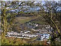
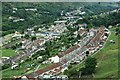
Overlooking New Tredegar
Looking down onto and across the Rhymney Valley.
Taken from a minor road from Tirphil that ascends Cefn y Brithdir, the ridge between the Rhymney Valley and the Darran Valley.
Image: © Robin Drayton
Taken: 21 Nov 2013
0.01 miles
3
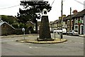
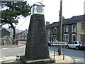
Clock Tower, New Tredegar
A plaque on the clock states "Erected in memory of the late Samuel Ronald MacMillan physician and surgeon by his grateful patients and friends".
Behind the clock are the terraces of Elliot's Town.
Image: © Robin Drayton
Taken: 12 Nov 2008
0.02 miles
6
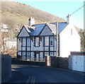
Elliot House, New Tredegar
Located on a bend in Bedwellty Road.
The name Elliot features in several locations in New Tredegar. Elliot's Colliery, (1888-1967) at its peak employed nearly 3,000 men. There is an Elliot Street nearby, and a district of the town is name Elliot's Town.
Image: © Jaggery
Taken: 20 Jan 2011
0.05 miles
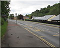
7
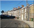
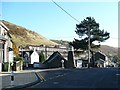
School Street, Elliot's Town, New Tredegar
A long row of houses occupy the NE side of the street. There is another School Street http://www.geograph.org.uk/photo/2243539 in New Tredegar, less than a kilometre away, in Tir-phil.
Image: © Jaggery
Taken: 20 Jan 2011
0.06 miles
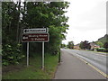
8
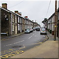
School Street, New Tredegar
In the Elliot's Town area of New Tredegar. On the left, a black arrow on a sign points towards Long Row.
Image: © Jaggery
Taken: 23 Jan 2016
0.06 miles
9
Rhosyn Gwyn bus stop, New Tredegar
Alongside the A4049 White Rose Way opposite Rhosyn Gwyn. In June 2019
the bus stop sign shows Route 2 to Bargoed and Route 12 to Blackwood.
Image: © Jaggery
Taken: 5 Jun 2019
0.06 miles
10
Phillipstown and Winding House direction signs, New Tredegar
Alongside the A4049 White Rose Way on the left here https://www.geograph.org.uk/photo/6182429 on the approach to the Cross Street junction. Winding House is Tŷ Weindio in Welsh.
Image: © Jaggery
Taken: 5 Jun 2019
0.06 miles