IMAGES TAKEN NEAR TO
Rhosyn Gwyn, White Rose Way, NEW TREDEGAR, NP24 6DD
Introduction
This page details the photographs taken nearby to Rhosyn Gwyn, White Rose Way, NP24 6DD by members of the Geograph project.
The Geograph project started in 2005 with the aim of publishing, organising and preserving representative images for every square kilometre of Great Britain, Ireland and the Isle of Man.

There are currently over 7.5m images from over14,400 individuals and you can help contribute to the project by visiting https://www.geograph.org.uk
Image Map
Images are licensed for reuse under creativecommons.org/licenses/by-sa/2.0
Notes
- Clicking on the map will re-center to the selected point.
- The higher the marker number, the further away the image location is from the centre of the postcode.
Image Listing (132 Images Found)
Images are licensed for reuse under creativecommons.org/licenses/by-sa/2.0
Image
Details
Distance
1
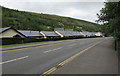
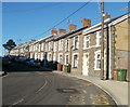
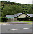
Rhosyn Gwyn bungalows, White Rose Way, New Tredegar
Bungalows in the cul-de-sac Rhosyn Gwyn viewed across the A4049 White Rose Way.
Image: © Jaggery
Taken: 5 Jun 2019
0.01 miles
2
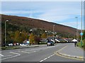
White Rose Way, New Tredegar
This is the A4049 and this section was built to divert through traffic away from residential streets in New Tredegar.
Image: © Robin Drayton
Taken: 10 Oct 2008
0.01 miles
3
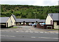
Rhosyn Gwyn, New Tredegar
Rhosyn Gwyn is a cul-de-sac on the south side of the A4049 White Rose Way.
Image: © Jaggery
Taken: 5 Jun 2019
0.01 miles
4
Rhosyn Gwyn bus stop, New Tredegar
Alongside the A4049 White Rose Way opposite Rhosyn Gwyn. In June 2019
the bus stop sign shows Route 2 to Bargoed and Route 12 to Blackwood.
Image: © Jaggery
Taken: 5 Jun 2019
0.01 miles
5
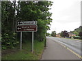
Phillipstown and Winding House direction signs, New Tredegar
Alongside the A4049 White Rose Way on the left here https://www.geograph.org.uk/photo/6182429 on the approach to the Cross Street junction. Winding House is Tŷ Weindio in Welsh.
Image: © Jaggery
Taken: 5 Jun 2019
0.01 miles
6
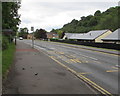
Low-pitched roofs, Rhosyn Gwyn, New Tredegar
Bungalows viewed across the A4049 White Rose Way on the approach to Elliots Town.
Image: © Jaggery
Taken: 5 Jun 2019
0.02 miles
7
Shelterless bus stop in New Tredegar
Alongside the A4049 White Rose Way near Rhosyn Gwyn.
Image: © Jaggery
Taken: 5 Jun 2019
0.03 miles
8
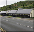
School Street, Elliot's Town, New Tredegar
A long row of houses occupy the NE side of the street. There is another School Street http://www.geograph.org.uk/photo/2243539 in New Tredegar, less than a kilometre away, in Tir-phil.
Image: © Jaggery
Taken: 20 Jan 2011
0.03 miles
9
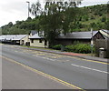
Green top of an electricity substation, White Rose Way, New Tredegar
The Western Power Distribution electricity substation is behind a wooden fence.
Image: © Jaggery
Taken: 5 Jun 2019
0.04 miles
10
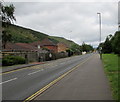
NW along White Rose Way, New Tredegar
Looking to the northwest along the A4049 White Rose Way towards the centre of New Tredegar.
Image: © Jaggery
Taken: 5 Jun 2019
0.06 miles