IMAGES TAKEN NEAR TO
Orchard Street, NEW TREDEGAR, NP24 6BU
Introduction
This page details the photographs taken nearby to Orchard Street, NP24 6BU by members of the Geograph project.
The Geograph project started in 2005 with the aim of publishing, organising and preserving representative images for every square kilometre of Great Britain, Ireland and the Isle of Man.

There are currently over 7.5m images from over14,400 individuals and you can help contribute to the project by visiting https://www.geograph.org.uk
Image Map
Images are licensed for reuse under creativecommons.org/licenses/by-sa/2.0
Notes
- Clicking on the map will re-center to the selected point.
- The higher the marker number, the further away the image location is from the centre of the postcode.
Image Listing (38 Images Found)
Images are licensed for reuse under creativecommons.org/licenses/by-sa/2.0
Image
Details
Distance
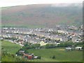
4
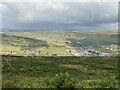
Phillip's Town
Looking north up the Rhymney valley.
Image: © Colin Bell
Taken: 25 Dec 2008
0.15 miles
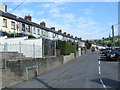
5
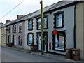
Phillipstown Post Office
Derlwyn Street.
The postbox is George V.
Although the PO sign says Phillipstown as do local direction signs, the OS uses Phillip's Town.
Image: © Robin Drayton
Taken: 19 Jun 2013
0.16 miles
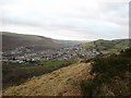
6
Sunlight across the Rhymney Valley
View towards New Tredegar.
Image: © Alan Hughes
Taken: 11 Jul 2023
0.19 miles
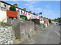
7
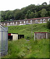
Powell's Terrace houses, New Tredegar
Viewed from the edge of Greenfield Street.
Image: © Jaggery
Taken: 17 Jun 2019
0.19 miles
8
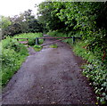
Metal barrier across a road into woodland, New Tredegar
On the right here. https://www.geograph.org.uk/photo/6464475
Image: © Jaggery
Taken: 17 Jun 2019
0.19 miles
9

Steps ascending from Tredegar Road, New Tredegar
Into the wood named Coed Cefn-rhychdir.
Image: © Jaggery
Taken: 17 Jun 2019
0.19 miles
10
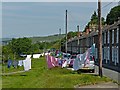
Hang out your washing on the former railway line
Powell's Terrace, New Tredegar.
With limited space to the rear of the houses, use is made of the open space on the other side of the road in front of the houses to hang the washing.
This was once the track of the Rhymney Branch of the Brecon and Merthyr Railway.
The line ceased operating in 1930 following a landslip to the north of this point.
See http://www.geograph.org.uk/photo/955781 for information.
Image: © Robin Drayton
Taken: 27 Jun 2013
0.19 miles