IMAGES TAKEN NEAR TO
Derlwyn Street, NEW TREDEGAR, NP24 6BA
Introduction
This page details the photographs taken nearby to Derlwyn Street, NP24 6BA by members of the Geograph project.
The Geograph project started in 2005 with the aim of publishing, organising and preserving representative images for every square kilometre of Great Britain, Ireland and the Isle of Man.

There are currently over 7.5m images from over14,400 individuals and you can help contribute to the project by visiting https://www.geograph.org.uk
Image Map
Images are licensed for reuse under creativecommons.org/licenses/by-sa/2.0
Notes
- Clicking on the map will re-center to the selected point.
- The higher the marker number, the further away the image location is from the centre of the postcode.
Image Listing (152 Images Found)
Images are licensed for reuse under creativecommons.org/licenses/by-sa/2.0
Image
Details
Distance
3
Ordnance Survey Cut Mark
This OS cut mark can be found on No80 Derlwyn Street. It marks a point 275.756m above mean sea level.
Image: © Adrian Dust
Taken: 20 Jul 2019
0.04 miles
4
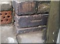
Ordnance Survey Cut Mark
This OS cut mark can be found on the wall right side of the steps, Fothergills Road. It marks a point 250.473m above mean sea level.
Image: © Adrian Dust
Taken: 20 Jul 2019
0.06 miles
5
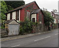
Derelict former Rechabite Hall, New Tredegar
Viewed across Duffryn Terrace in June 2019. The inscription on the roundel is RECHABITE HALL 1893. https://www.geograph.org.uk/photo/6187474
Rechabite is the name used by Christian groups promoting total abstinence from alcohol.
Image: © Jaggery
Taken: 17 Jun 2019
0.11 miles
6
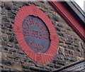
Rechabite Hall 1893 inscription, New Tredegar
On this https://www.geograph.org.uk/photo/6187471 derelict building.
Image: © Jaggery
Taken: 17 Jun 2019
0.11 miles
7
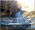
Nant Syfiog, New Tredegar
Viewed from near Bedwellty Road. Looking along an artificial channel towards a weir. The stream is Nant Syfiog.
Image: © Jaggery
Taken: 20 Jan 2011
0.11 miles
9
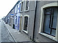
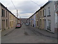
Stone houses, Duffryn Terrace, New Tredegar
Alongside the ascent towards Elliot's Town.
Image: © Jaggery
Taken: 17 Jun 2019
0.11 miles
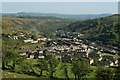
10
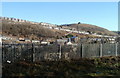
High ground, New Tredegar, viewed from Tir-Phil railway station
The view NE from Tir-Phil station http://www.geograph.org.uk/photo/2243473 on a clear, sunny day in mid-January.
Image: © Jaggery
Taken: 20 Jan 2011
0.11 miles