IMAGES TAKEN NEAR TO
Glan Yr Afon, Ruperra Street, NEW TREDEGAR, NP24 6AR
Introduction
This page details the photographs taken nearby to Glan Yr Afon, Ruperra Street, NP24 6AR by members of the Geograph project.
The Geograph project started in 2005 with the aim of publishing, organising and preserving representative images for every square kilometre of Great Britain, Ireland and the Isle of Man.

There are currently over 7.5m images from over14,400 individuals and you can help contribute to the project by visiting https://www.geograph.org.uk
Image Map
Images are licensed for reuse under creativecommons.org/licenses/by-sa/2.0
Notes
- Clicking on the map will re-center to the selected point.
- The higher the marker number, the further away the image location is from the centre of the postcode.
Image Listing (257 Images Found)
Images are licensed for reuse under creativecommons.org/licenses/by-sa/2.0
Image
Details
Distance
1
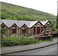
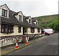
East side of Glan yr Afon, New Tredegar
Located between Ruperra Street and the Rhymney River,
Glan yr Afon is sheltered/retirement housing built in 1986.
Image: © Jaggery
Taken: 17 Jun 2019
0.01 miles
2
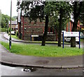
Entrance to Glan yr Afon, New Tredegar
From Ruperra Street. Located on the east bank of the Rhymney River,
Glan yr Afon is sheltered/retirement housing built in 1986.
Image: © Jaggery
Taken: 17 Jun 2019
0.02 miles
3
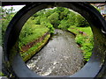
Downstream along the Rhymney River, New Tredegar
Looking south from this https://www.geograph.org.uk/photo/6186022 road bridge.
Image: © Jaggery
Taken: 17 Jun 2019
0.03 miles
4
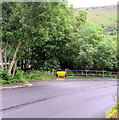
Yellow grit/salt box, Ruperra Street, New Tredegar
Alongside the descent from Commercial Street to the Rhymney River.
Image: © Jaggery
Taken: 17 Jun 2019
0.03 miles
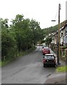
5
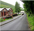
Into the valley of the Rhymney River, New Tredegar
From Commercial Street on higher ground, Ruperra Street descends
towards the Rhymney River past Glan yr Afon sheltered/retirement housing.
Image: © Jaggery
Taken: 17 Jun 2019
0.03 miles
6
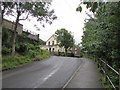
Up Ruperra Street, New Tredegar
Ruperra Street ascends from the valley of the Rhymney River
towards a Presbyterian Church of Wales church. https://www.geograph.org.uk/photo/6185951
Image: © Jaggery
Taken: 17 Jun 2019
0.03 miles
7
Distinctive house, Chapel Street, New Tredegar
Viewed from the corner of Greenfield Street.
Image: © Jaggery
Taken: 17 Jun 2019
0.04 miles
8
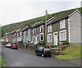
Stone houses, Sunnybank, Tirphil
The houses are opposite the Rhymney River.
Image: © Jaggery
Taken: 17 Jun 2019
0.04 miles
9
Sunnybank, Tirphil
The road named Sunnybank ascends towards James Street.
The trees are on a bank of the Rhymney River.
Image: © Jaggery
Taken: 17 Jun 2019
0.04 miles
10
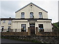
Presbyterian Church of Wales church, Ruperra Street, New Tredegar
Formerly Bethel Calvinstic Methodist Chapel. Bethel was erected in 1860.
Image: © Jaggery
Taken: 17 Jun 2019
0.04 miles