IMAGES TAKEN NEAR TO
Ruperra Street, NEW TREDEGAR, NP24 6AG
Introduction
This page details the photographs taken nearby to Ruperra Street, NP24 6AG by members of the Geograph project.
The Geograph project started in 2005 with the aim of publishing, organising and preserving representative images for every square kilometre of Great Britain, Ireland and the Isle of Man.

There are currently over 7.5m images from over14,400 individuals and you can help contribute to the project by visiting https://www.geograph.org.uk
Image Map (Loading...)


Getting Data...Please wait
Leaflet Map data © OpenStreetMap
Images are licensed for reuse under creativecommons.org/licenses/by-sa/2.0
Notes
- Clicking on the map will re-center to the selected point.
- The higher the marker number, the further away the image location is from the centre of the postcode.
Image Listing (255 Images Found)
Images are licensed for reuse under creativecommons.org/licenses/by-sa/2.0
Image
Details
Distance
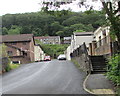
1
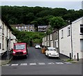
Eastern end of Ruperra Street, New Tredegar
Viewed across Commercial Street. Ruperra Street ends at steps up to a footpath/cycleway.
Tredegar Road houses are in the background.
Image: © Jaggery
Taken: 17 Jun 2019
0.01 miles
2
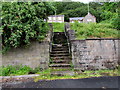
Steps beyond the eastern end of Ruperra Street, New Tredegar
In the background here https://www.geograph.org.uk/photo/6185516 steps ascend to a footpath/cycleway which is part
of National Cycle Network Route 468. Tredegar Road houses are in the background.
Image: © Jaggery
Taken: 17 Jun 2019
0.01 miles
3
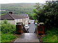
Top of steps down to Ruperra Street, New Tredegar
From a combined footpath/cycleway. Ruperra Street leads to Commercial Street.
Image: © Jaggery
Taken: 17 Jun 2019
0.01 miles
4
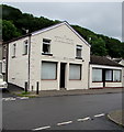
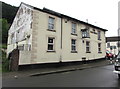
Late Victorian building on a New Tredegar corner
The year 1897 is embossed on the Commercial Street side of the building on the corner of Ruperra Street.
Image: © Jaggery
Taken: 17 Jun 2019
0.01 miles
5
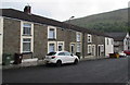
Row of stone houses, Ruperra Street, New Tredegar
Looking towards Commercial Street.
Image: © Jaggery
Taken: 17 Jun 2019
0.01 miles
6
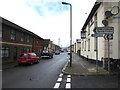
New Tredegar Sports Centre direction sign
On the corner of Ruperra Street and Commercial Street at the edge
of the Ruperra pub. A smaller sign points towards Glan-yr-Afon.
Image: © Jaggery
Taken: 17 Jun 2019
0.01 miles
7
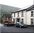
Ruperra Street side of the Ruperra pub, New Tredegar
The south side of this https://www.geograph.org.uk/photo/6185485 Commercial Street pub.
Image: © Jaggery
Taken: 17 Jun 2019
0.01 miles
8
The Ruperra, Commercial Street, New Tredegar
Commercial Street side of the pub on the corner of Ruperra Street. https://www.geograph.org.uk/photo/6185491 to the name sign.
Image: © Jaggery
Taken: 17 Jun 2019
0.02 miles
9
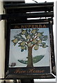
The Ruperra name sign, New Tredegar
On a wall bracket here. https://www.geograph.org.uk/photo/6185485
Image: © Jaggery
Taken: 17 Jun 2019
0.02 miles
10
Ruperra Street towards Commercial Street, New Tredegar
The steps ascend towards a church. https://www.geograph.org.uk/photo/6185951
Image: © Jaggery
Taken: 17 Jun 2019
0.02 miles