IMAGES TAKEN NEAR TO
Thomas Street, NEW TREDEGAR, NP24 6AF
Introduction
This page details the photographs taken nearby to Thomas Street, NP24 6AF by members of the Geograph project.
The Geograph project started in 2005 with the aim of publishing, organising and preserving representative images for every square kilometre of Great Britain, Ireland and the Isle of Man.

There are currently over 7.5m images from over14,400 individuals and you can help contribute to the project by visiting https://www.geograph.org.uk
Image Map
Images are licensed for reuse under creativecommons.org/licenses/by-sa/2.0
Notes
- Clicking on the map will re-center to the selected point.
- The higher the marker number, the further away the image location is from the centre of the postcode.
Image Listing (262 Images Found)
Images are licensed for reuse under creativecommons.org/licenses/by-sa/2.0
Image
Details
Distance
1
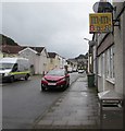
M&Ms sign on a New Tredegar corner
In June 2019 a relic of a former shop remains on the corner of Commercial Street and Ruperra Street.
Image: © Jaggery
Taken: 17 Jun 2019
0.02 miles
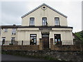
2
Late Victorian building on a New Tredegar corner
The year 1897 is embossed on the Commercial Street side of the building on the corner of Ruperra Street.
Image: © Jaggery
Taken: 17 Jun 2019
0.02 miles
3
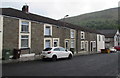
Row of stone houses, Ruperra Street, New Tredegar
Looking towards Commercial Street.
Image: © Jaggery
Taken: 17 Jun 2019
0.02 miles
4
Houses and church, Ruperra Street, New Tredegar
Bethel Presbyterian Church of Wales church https://www.geograph.org.uk/photo/6185951 is on the right.
Image: © Jaggery
Taken: 17 Jun 2019
0.02 miles
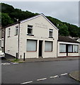
5
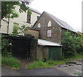
Derelict building, Ruperra Street, New Tredegar
Its location next to a Presbyterian Church of Wales church https://www.geograph.org.uk/photo/6185951
suggests that this building may have been a church hall. Viewed in June 2019.
Image: © Jaggery
Taken: 17 Jun 2019
0.02 miles
6
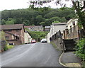
Ruperra Street towards Commercial Street, New Tredegar
The steps ascend towards a church. https://www.geograph.org.uk/photo/6185951
Image: © Jaggery
Taken: 17 Jun 2019
0.02 miles
7
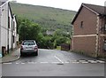
Junction of Ruperra Street and Commercial Street, New Tredegar
Ruperra Street descends towards the valley of the Rhymney River.
Image: © Jaggery
Taken: 17 Jun 2019
0.02 miles
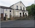
8
Presbyterian Church of Wales church, Ruperra Street, New Tredegar
Formerly Bethel Calvinstic Methodist Chapel. Bethel was erected in 1860.
Image: © Jaggery
Taken: 17 Jun 2019
0.03 miles
9
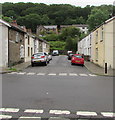
Eastern part of Thomas Street, New Tredegar
Viewed across Commercial Street from broken white lines across the western part of Thomas Street. https://www.geograph.org.uk/photo/6188972
Tredegar Road houses are in the background.
Image: © Jaggery
Taken: 17 Jun 2019
0.03 miles
10
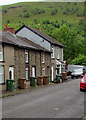
Thomas Street houses and wheelie bins, New Tredegar
This part of Thomas Street is on the west side of Commercial Street.
Image: © Jaggery
Taken: 17 Jun 2019
0.03 miles