IMAGES TAKEN NEAR TO
Festival Drive, EBBW VALE, NP23 8XF
Introduction
This page details the photographs taken nearby to Festival Drive, NP23 8XF by members of the Geograph project.
The Geograph project started in 2005 with the aim of publishing, organising and preserving representative images for every square kilometre of Great Britain, Ireland and the Isle of Man.

There are currently over 7.5m images from over14,400 individuals and you can help contribute to the project by visiting https://www.geograph.org.uk
Image Map
Images are licensed for reuse under creativecommons.org/licenses/by-sa/2.0
Notes
- Clicking on the map will re-center to the selected point.
- The higher the marker number, the further away the image location is from the centre of the postcode.
Image Listing (37 Images Found)
Images are licensed for reuse under creativecommons.org/licenses/by-sa/2.0
Image
Details
Distance
1
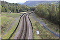
Ebbw Valley Railway, Ebbw Vale
Looking south towards Ebbw Vale Parkway from a bridge Image The bridge carrying the A4046 over the line can just be seen in the distance. The land either side of the line was once part of a steelworks.
Image: © M J Roscoe
Taken: 3 Oct 2017
0.05 miles
2
Ebbw Valley Railway, Ebbw Vale
Railway line between the two Ebbw Vale stations in the central valley on the site of the former steelworks, looking south.
Image: © M J Roscoe
Taken: 23 Feb 2016
0.08 miles
3
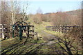
Track alongside end of Central Valley LNR
Track, with restricted vehicle access, on the embankment along the southern end of Gwent Wildlife Trust's reserve.
Image: © M J Roscoe
Taken: 14 Feb 2019
0.10 miles
4
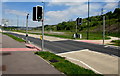
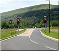
Pelican crossing, Ebbw Vale
Chambers Dictionary states that the term pelican crossing is adapted from "pedestrian light controlled crossing".
There has been much regeneration hereabouts, in the large site formerly occupied by Ebbw Vale steelworks.
This new (or perhaps newly resurfaced) road isn't named on maps I've consulted. Its course is parallel with Steel Works Road to the east.
Image: © Jaggery
Taken: 27 May 2015
0.12 miles
5
Southern end of Strand Annealing Lane, Ebbw Vale
Built c2011, Strand Annealing Lane extends for 650 metres from the junction http://www.geograph.org.uk/photo/4514950 in Tyllwyn
at its northern end to the junction ahead. It is the Ebbw Fawr Learning Community http://www.geograph.org.uk/photo/3666228 access road.
Image: © Jaggery
Taken: 27 May 2015
0.12 miles
7
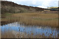
Pond, Central Valley, Ebbw Vale
Pond at end of Central Valley Wetlands, now part of the Furnace to Flowers project managed by Gwent Wildlife Trust. The valley side to the left will be planted/sown with wild flowers.
Image: © M J Roscoe
Taken: 23 Feb 2016
0.14 miles
8
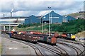
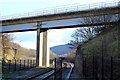
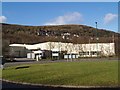
The Railway yard at Ebbw Vale works
The Passenger railway has re-opened to Ebbw Vale just recently. This picture shows the freight yard at Ebbw Vale with the tinplate works belonging to then British Steel situated behind the yard. This was the reason for the railway surviving to transport steel products up the valley and back for processing at the works. Now the passenger trains are back but the freight has gone. Plenty of wagons on hand when this picture was taken. This was in fact a relative new yard as the old sidings were cleared for the garden festival held at Ebbw Vale. Do you remember that?
Image: © roger geach
Taken: 18 Sep 1991
0.14 miles
9
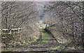
Track down into Central Valley LNR
Star of track down from embankment track Image at the southern end of Gwent Wildlife Trust's reserve, on reclaimed landscaped industrial land.
Image: © M J Roscoe
Taken: 14 Feb 2019
0.15 miles
10

Disused section of road in the former Ebbw Vale Steelworks site
Disconnected from the southern end of Strand Annealing Lane, as shown here. http://www.geograph.org.uk/photo/4515145
Image: © Jaggery
Taken: 27 May 2015
0.15 miles