IMAGES TAKEN NEAR TO
Acorn Villas, EBBW VALE, NP23 8AW
Introduction
This page details the photographs taken nearby to Acorn Villas, NP23 8AW by members of the Geograph project.
The Geograph project started in 2005 with the aim of publishing, organising and preserving representative images for every square kilometre of Great Britain, Ireland and the Isle of Man.

There are currently over 7.5m images from over14,400 individuals and you can help contribute to the project by visiting https://www.geograph.org.uk
Image Map
Images are licensed for reuse under creativecommons.org/licenses/by-sa/2.0
Notes
- Clicking on the map will re-center to the selected point.
- The higher the marker number, the further away the image location is from the centre of the postcode.
Image Listing (91 Images Found)
Images are licensed for reuse under creativecommons.org/licenses/by-sa/2.0
Image
Details
Distance
1
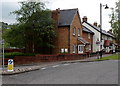
Acorn Villas, Victoria, Ebbw Vale
Viewed across The Boulevard. A sign on the left points towards Ebbw Vale Parkway railway station.
Image: © Jaggery
Taken: 16 May 2014
0.03 miles
2
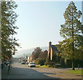
The Boulevard, Ebbw Vale
A view SE along The Boulevard in the Victoria district of Ebbw Vale. The tall tree on the right is on the corner of Howards Way.
Image: © Jaggery
Taken: 29 Sep 2011
0.05 miles
3
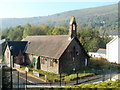
Glan Ebbw Terrace, Victoria, Ebbw Vale
This is the southern side of Glan Ebbw Terrace. Nearest the camera is the former St Mary's Church, http://www.geograph.org.uk/photo/2624666 now converted into 3 flats.
Image: © Jaggery
Taken: 29 Sep 2011
0.05 miles
4
South along Glan Ebbw Terrace, Victoria, Ebbw Vale
Looking past the former St Mary's Church http://www.geograph.org.uk/photo/2624666 towards the southern end of Glan Ebbw Terrace 100 metres ahead. At the left edge of the view are vegetation and a fence beyond which is the Ebbw River.
Image: © Jaggery
Taken: 16 May 2014
0.05 miles
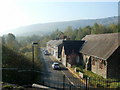
5
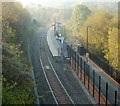
Ebbw Vale Parkway railway station
Viewed from a footbridge. http://www.geograph.org.uk/photo/2624568
Opened in February 2008, the single-platform station is currently (end-September 2011) the northern terminus of the Ebbw Valley Railway route from Cardiff Central.
The physical end of the line http://www.geograph.org.uk/photo/2624600 is about 200 metres north of the station, behind the camera.
A feasibility study to extend the line northwards to a new station at Ebbw Vale Town has been commissioned by the Welsh Assembly Government.
Image: © Jaggery
Taken: 29 Sep 2011
0.06 miles
6
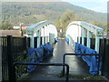
Footbridge near Ebbw Vale Parkway railway station
Viewed from the Station Road (A4046) side. The footbridge leads to Glan Ebbw Terrace and the railway station. http://www.geograph.org.uk/photo/2624631
Image: © Jaggery
Taken: 29 Sep 2011
0.06 miles
7
Flats in former church, Victoria, Ebbw Vale
The former St Mary's Church, Glan Ebbw Terrace, has been divided into 3 flats. Flats 1 and 2 are on the left, number 3 is on the right. Viewed from a footbridge. http://www.geograph.org.uk/photo/2624568
Image: © Jaggery
Taken: 29 Sep 2011
0.06 miles
8
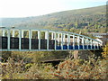
Two footbridges near Ebbw Vale Parkway railway station
Viewed from the Station Road (A4046) side. The bridges at different levels cross the single-track railway line http://www.geograph.org.uk/photo/2624631 and the Ebbw River.
Image: © Jaggery
Taken: 29 Sep 2011
0.06 miles
9
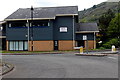
Northern end of Baldwin House, Ebbw Vale
Blaenau Gwent County Borough Council offices in Victoria Business Park.
Image: © Jaggery
Taken: 16 May 2014
0.06 miles
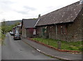
10
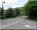
West along Glan Ebbw Terrace, Ebbw Vale
Towards the roundabout at the junction with The Boulevard.
Image: © Jaggery
Taken: 27 May 2015
0.06 miles