IMAGES TAKEN NEAR TO
New Cwm Terrace, EBBW VALE, NP23 7RS
Introduction
This page details the photographs taken nearby to New Cwm Terrace, NP23 7RS by members of the Geograph project.
The Geograph project started in 2005 with the aim of publishing, organising and preserving representative images for every square kilometre of Great Britain, Ireland and the Isle of Man.

There are currently over 7.5m images from over14,400 individuals and you can help contribute to the project by visiting https://www.geograph.org.uk
Image Map
Images are licensed for reuse under creativecommons.org/licenses/by-sa/2.0
Notes
- Clicking on the map will re-center to the selected point.
- The higher the marker number, the further away the image location is from the centre of the postcode.
Image Listing (34 Images Found)
Images are licensed for reuse under creativecommons.org/licenses/by-sa/2.0
Image
Details
Distance
1
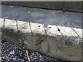
Ordnance Survey Rivet
This OS rivet can be found on the step SE side of the road. Originally the step of the Drill Hall which has now gone. It marks a point 231.880m above mean sea level.
Image: © Adrian Dust
Taken: 4 Aug 2018
0.04 miles
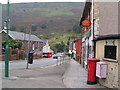
3
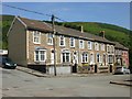
Bailey Street, Cwm
Houses at the eastern end of Bailey Street, viewed from the corner of Cendl Terrace.
Image: © Jaggery
Taken: 23 Jun 2010
0.08 miles
4
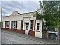
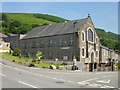
Cwm : St Paul's Church parish hall
Located on Station Terrace, about 350 metres south east of the church. http://www.geograph.org.uk/photo/1931912
Image: © Jaggery
Taken: 23 Jun 2010
0.08 miles
6
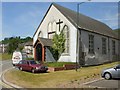
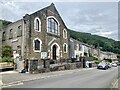
Tirzah Baptist Church, Cwm
On the corner of Station Terrace http://www.geograph.org.uk/photo/1931985 and Mill Terrace.
Biblical references to Tirzah are to either a town in the Samarian highlands, or one of the five daughters of Zelophehad.
Image: © Jaggery
Taken: 23 Jun 2010
0.08 miles
8
Site of Cwm station Ebbw Vale line, 1990
View southward, towards Aberbeeg and Newport: ex-GW Western Valleys line, Newport - Risca - Aberbeeg - Ebbw Vale. The station was closed along with the passenger service on 30/4/62, but the line remained for freight traffic, latterly only for Ebbw Vale steelworks. From 6/2/08, a passenger service was restored to Ebbw Vale (Parkway), but from Cardiff Central via Park Junction (west of Newport) and a new station has yet to be provided at Cwm.
Image: © Ben Brooksbank
Taken: 19 May 1990
0.11 miles
10
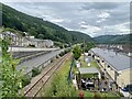
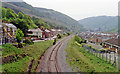
Road, rail and housing in Cwm
Typical Welsh valleys community - below Ebbw Vale.
Image: © Alan Hughes
Taken: 13 Aug 2024
0.12 miles