IMAGES TAKEN NEAR TO
School Terrace, EBBW VALE, NP23 7QY
Introduction
This page details the photographs taken nearby to School Terrace, NP23 7QY by members of the Geograph project.
The Geograph project started in 2005 with the aim of publishing, organising and preserving representative images for every square kilometre of Great Britain, Ireland and the Isle of Man.

There are currently over 7.5m images from over14,400 individuals and you can help contribute to the project by visiting https://www.geograph.org.uk
Image Map
Images are licensed for reuse under creativecommons.org/licenses/by-sa/2.0
Notes
- Clicking on the map will re-center to the selected point.
- The higher the marker number, the further away the image location is from the centre of the postcode.
Image Listing (38 Images Found)
Images are licensed for reuse under creativecommons.org/licenses/by-sa/2.0
Image
Details
Distance
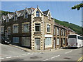
1

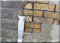
Ordnance Survey Cut Mark
This OS cut mark can be found on the Bailey Arms. It marks a point 228.103m above mean sea level.
Image: © Adrian Dust
Taken: 4 Aug 2018
0.03 miles
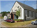
2
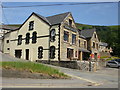
Baileys Arms, Cwm
Pub on the corner of School Terrace and Emlyn Road.
Image: © Jaggery
Taken: 23 Jun 2010
0.04 miles
3
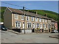
Bailey Street, Cwm
Houses at the eastern end of Bailey Street, viewed from the corner of Cendl Terrace.
Image: © Jaggery
Taken: 23 Jun 2010
0.06 miles
4
Cwm : corner of School Terrace and Cendl Terrace
A Clarkes coach descends along School Terrace ; on the left Cendl Terrace begins its climb towards Cwm cemetery.
Image: © Jaggery
Taken: 23 Jun 2010
0.06 miles
5
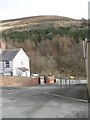
Cools Close
Looking towards Cefn yr Arail.
Image: © Burgess Von Thunen
Taken: 6 Feb 2013
0.11 miles
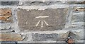
6
Ordnance Survey Cut Mark
This OS cut mark can be found on No24 Cerdl Terrace. It marks a point 239.936m above mean sea level.
Image: © Adrian Dust
Taken: 4 Aug 2018
0.11 miles
7
Cwm : St Paul's Church parish hall
Located on Station Terrace, about 350 metres south east of the church. http://www.geograph.org.uk/photo/1931912
Image: © Jaggery
Taken: 23 Jun 2010
0.12 miles
8
Ordnance Survey Cut Mark
This OS cut mark can be found on No50 Canning Street. It marks a point 208.258m above mean sea level.
Image: © Adrian Dust
Taken: 4 Aug 2018
0.12 miles
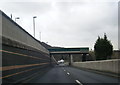
10
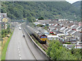
Railtour at Cwm
UK Railtours brought a pair of class 66 locomotives, Nos. 66011 and 66116, in top-and-tail formation, to South Wales on their Valley Legend railtour. The tour visited the Ebbw Vale and Tower Colliery branches, and is seen here heading past the village of Cwm on its way to Ebbw Vale.
Image: © Gareth James
Taken: 30 Jul 2017
0.12 miles