IMAGES TAKEN NEAR TO
Civic Centre, EBBW VALE, NP23 6XR
Introduction
This page details the photographs taken nearby to Civic Centre, NP23 6XR by members of the Geograph project.
The Geograph project started in 2005 with the aim of publishing, organising and preserving representative images for every square kilometre of Great Britain, Ireland and the Isle of Man.

There are currently over 7.5m images from over14,400 individuals and you can help contribute to the project by visiting https://www.geograph.org.uk
Image Map
Images are licensed for reuse under creativecommons.org/licenses/by-sa/2.0
Notes
- Clicking on the map will re-center to the selected point.
- The higher the marker number, the further away the image location is from the centre of the postcode.
Image Listing (95 Images Found)
Images are licensed for reuse under creativecommons.org/licenses/by-sa/2.0
Image
Details
Distance
1

Old Milestone by the B4486/A4281, Cemetery Road, Ebbw Vale
Iron casting on a stone base by the B4486/A4281, in parish of Ebbw Vale (Blaenau Gwent County Borough District), Cemetery Road, Pont-y-Gôf, East side of road, in front of black railings.
Inscription reads:-
: ( ?? / ?? ) : : EBBW VALE / E.V.L.B.D. : : NEWPORT / ( 2? ) :
Surveyed
Milestone Society National ID: MON_AGNP11
Image: © Milestone Society
Taken: Unknown
0.04 miles
2

Ebbw Vale Civic Centre
Blaenau Gwent County Borough Council offices are in Municipal Offices, Ebbw Vale.
Image: © Jaggery
Taken: 10 Sep 2013
0.07 miles
3
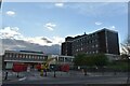
Ebbw Vale Civic Centre
Originally built in the 1960's on reclaimed land, the Civic Centre served Ebbw Vale Urban District Council, Blaenau Gwent Borough Council and then Blaenau Gwent County Borough Council which was formed in 1996. Its days are now numbered as it is currently being stripped out prior to demolition. The demolition of the nearby Leisure Centre back in 2014 makes this a very bare and sad part of Ebbw Vale.
Image: © Colin Cheesman
Taken: 17 Nov 2022
0.07 miles
4
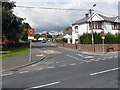
Emlyn Avenue, Ebbw Vale
Looking across Beaufort Road along the SE end of Emlyn Avenue, where there is a 20mph maximum speed zone.
Image: © Jaggery
Taken: 10 Sep 2013
0.07 miles
5
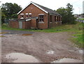
Army Cadet Force (ACF) building in Ebbw Vale
Located between Beaufort Road and the Ebbw River.
One nameplate on the wall shows GWENT ACF EBBW VALE DETACHMENT.
The one below it shows GWENT AND POWYS ACF.
Image: © Jaggery
Taken: 10 Sep 2017
0.07 miles
6
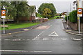
Evelyn Avenue, Ebbw Vale
The southeast end of Evelyn Avenue viewed across Beaufort Road.
The 30mph speed limit drops to 20mph ahead. PARTH on the signs is Welsh for ZONE.
Image: © Jaggery
Taken: 10 Sep 2017
0.08 miles
7

Army Cadet Force building in Ebbw Vale
Viewed across Beaufort Road. One nameplate on the wall shows GWENT ACF EBBW VALE DETACHMENT. The one below it shows GWENT AND POWYS ACF.
The building is shown on some maps as a Gospel Hall, which probably explains why the ACF building is not (yet) enclosed by a perimeter fence like most other ACF buildings.
Image: © Jaggery
Taken: 10 Sep 2013
0.08 miles
8

Directions sign near the southern end of Beaufort Road, Ebbw Vale
On the approach to the A4281 junction, the sign is partly hidden by vegetation in early September 2017.
Image: © Jaggery
Taken: 10 Sep 2017
0.08 miles
9
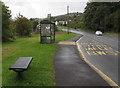
Beaufort Road bus stop and shelter, Ebbw Vale
This side of the road for buses to the town centre.
Image: © Jaggery
Taken: 10 Sep 2017
0.08 miles
10
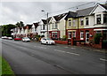
Beaufort Road semis, Ebbw Vale
Semi-detached houses on the west side of Beaufort Road.
Image: © Jaggery
Taken: 10 Sep 2017
0.09 miles