IMAGES TAKEN NEAR TO
Waun-y-Pound Industrial Estate, EBBW VALE, NP23 6XQ
Introduction
This page details the photographs taken nearby to Waun-y-Pound Industrial Estate, NP23 6XQ by members of the Geograph project.
The Geograph project started in 2005 with the aim of publishing, organising and preserving representative images for every square kilometre of Great Britain, Ireland and the Isle of Man.

There are currently over 7.5m images from over14,400 individuals and you can help contribute to the project by visiting https://www.geograph.org.uk
Image Map (8 Images)


Getting Data...Please wait
Leaflet Map data © OpenStreetMap
Images are licensed for reuse under creativecommons.org/licenses/by-sa/2.0
Notes
- Clicking on the map will re-center to the selected point.
- The higher the marker number, the further away the image location is from the centre of the postcode.
Image Listing (8 Images Found)
Images are licensed for reuse under creativecommons.org/licenses/by-sa/2.0
Image
Details
Distance
7
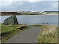
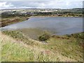
Path to the upper lake at Blue Lakes.
The approach to the upper of the three lakes from the Aneurin Bevan Memorial stones http://www.geograph.org.uk/photo/2615734 .
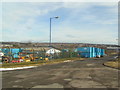
The Rassau Industrial Estate at Image is in the distance.
Image: © Robin Drayton
Taken: 21 Sep 2011
0.24 miles
8
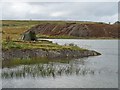
Fishing on the upper lake at Blue Lakes
A lone fishing tent giving protection from the westerly winds at this exposed location.
Image: © Robin Drayton
Taken: 21 Sep 2011
0.25 miles