IMAGES TAKEN NEAR TO
Cwm Road, EBBW VALE, NP23 6TR
Introduction
This page details the photographs taken nearby to Cwm Road, NP23 6TR by members of the Geograph project.
The Geograph project started in 2005 with the aim of publishing, organising and preserving representative images for every square kilometre of Great Britain, Ireland and the Isle of Man.

There are currently over 7.5m images from over14,400 individuals and you can help contribute to the project by visiting https://www.geograph.org.uk
Image Map
Images are licensed for reuse under creativecommons.org/licenses/by-sa/2.0
Notes
- Clicking on the map will re-center to the selected point.
- The higher the marker number, the further away the image location is from the centre of the postcode.
Image Listing (29 Images Found)
Images are licensed for reuse under creativecommons.org/licenses/by-sa/2.0
Image
Details
Distance
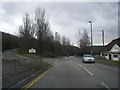
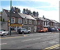
2
A4046 Newport to Ebbw Vale
Near the Waunlwyd Youth Community Centre.
Image: © Alan Hughes
Taken: 13 Aug 2024
0.07 miles
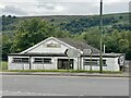
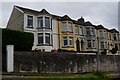
5
Smiling Valley, Waunlwyd
Chinese takeaway at 7 Park Place, Waunlwyd.
Image: © Jaggery
Taken: 10 Sep 2013
0.13 miles
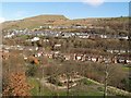
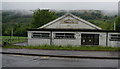
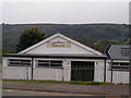
10
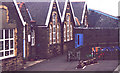
Waunlwyd Primary School
Another view of the school, showing the entrance to the Headmaster's Office - it was Mr Killey in my day - a place of imagined horrors!
Image: © David Harris
Taken: 19 Mar 2001
0.18 miles