IMAGES TAKEN NEAR TO
Tredegar Road, EBBW VALE, NP23 6PQ
Introduction
This page details the photographs taken nearby to Tredegar Road, NP23 6PQ by members of the Geograph project.
The Geograph project started in 2005 with the aim of publishing, organising and preserving representative images for every square kilometre of Great Britain, Ireland and the Isle of Man.

There are currently over 7.5m images from over14,400 individuals and you can help contribute to the project by visiting https://www.geograph.org.uk
Image Map
Images are licensed for reuse under creativecommons.org/licenses/by-sa/2.0
Notes
- Clicking on the map will re-center to the selected point.
- The higher the marker number, the further away the image location is from the centre of the postcode.
Image Listing (10 Images Found)
Images are licensed for reuse under creativecommons.org/licenses/by-sa/2.0
Image
Details
Distance
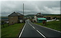
5
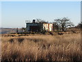
Agricultural building near Mountain Air Gate
Image: © Gareth James
Taken: 28 Dec 2016
0.18 miles
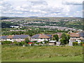
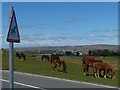
7
Horses grazing on Manmoel Common
The houses below the horses are in the Mountain Air district of Ebbw Vale.
In the far distance is Rassau and its industrial estate and beyond that the moorland of Mynydd Llangynidr.
Image: © Robin Drayton
Taken: 15 May 2014
0.20 miles
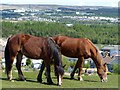
8
Warning ? Horses
On a minor road from Ebbw Vale to Tredegar crossing Manmoel Common.
Image: © Robin Drayton
Taken: 15 May 2014
0.20 miles
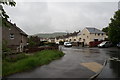
9
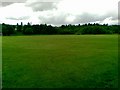
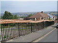
Hilltop Stadium Recreation Ground, Willowtown
Image: © Alex McGregor
Taken: 9 Jun 2011
0.21 miles