IMAGES TAKEN NEAR TO
Bryn Deri, EBBW VALE, NP23 6NU
Introduction
This page details the photographs taken nearby to Bryn Deri, NP23 6NU by members of the Geograph project.
The Geograph project started in 2005 with the aim of publishing, organising and preserving representative images for every square kilometre of Great Britain, Ireland and the Isle of Man.

There are currently over 7.5m images from over14,400 individuals and you can help contribute to the project by visiting https://www.geograph.org.uk
Image Map
Images are licensed for reuse under creativecommons.org/licenses/by-sa/2.0
Notes
- Clicking on the map will re-center to the selected point.
- The higher the marker number, the further away the image location is from the centre of the postcode.
Image Listing (20 Images Found)
Images are licensed for reuse under creativecommons.org/licenses/by-sa/2.0
Image
Details
Distance
1
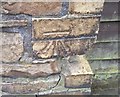
Ordnance Survey Cut Mark
This OS cut mark can be found on the wall SW side of Pennant Street. It marks a point 331.171m above mean sea level.
Image: © Adrian Dust
Taken: 18 Aug 2018
0.16 miles

4
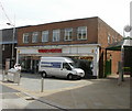
Former Woolworths, Ebbw Vale
The presence of a flooring services van outside the former Woolworths at 32 Bethcar Street suggests that the premises may have acquired a new owner.
The premises have been unused since all UK Woolworth stores ceased trading at the start of January 2009.
Image: © Jaggery
Taken: 28 Apr 2010
0.21 miles
5
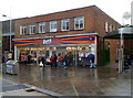
B&M Bargains in former Woolworths, Ebbw Vale
This building at 32 Bethcar Street was formerly a Woolworths Store. http://www.geograph.org.uk/photo/1175140
Formed in 1976 in Blackpool, Lancashire, B&M now (2011) has nearly 300 stores in the UK.
Image: © Jaggery
Taken: 17 Dec 2011
0.21 miles
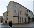
6
Ebbw Vale Post Office
Located in central Ebbw Vale at 63 Bethcar Street.
The adjoining premises are in use as a campaign office for the 2010 General Election. The photo was taken eight days before polling day.
Image: © Jaggery
Taken: 28 Apr 2010
0.22 miles
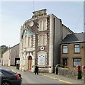
7
Ebbw Vale Conservative Club
Located at 40 Bethcar Street.
Image: © Jaggery
Taken: 17 Dec 2011
0.22 miles
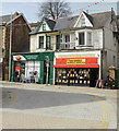
8
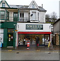
Sweets & Things, Ebbw Vale
Sweet shop at 61 Bethcar Street, next door to the post office. http://www.geograph.org.uk/photo/1830249 61 Bethcar Street has had various recent uses, including as a political campaign office and as Forget Me Not florists.
Image: © Jaggery
Taken: 17 Dec 2011
0.22 miles
9
Ebbw Vale Library
Located in the centre of town at 21 Bethcar Street. Part of Blaenau Gwent County Borough Council's library service.
Image: © Jaggery
Taken: 28 Apr 2010
0.22 miles
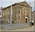
10
Former Workmen's Hall, Ebbw Vale
Located alongside a narrow lane behind the library http://www.geograph.org.uk/photo/1830232 is the now boarded-up Workmen's Club, built in 1907. Following a pattern seen elsewhere, the original club and theatre became a cinema and then a bingo hall before closing down.
Image: © Jaggery
Taken: 28 Apr 2010
0.22 miles