IMAGES TAKEN NEAR TO
Brynheulog Street, EBBW VALE, NP23 6JY
Introduction
This page details the photographs taken nearby to Brynheulog Street, NP23 6JY by members of the Geograph project.
The Geograph project started in 2005 with the aim of publishing, organising and preserving representative images for every square kilometre of Great Britain, Ireland and the Isle of Man.

There are currently over 7.5m images from over14,400 individuals and you can help contribute to the project by visiting https://www.geograph.org.uk
Image Map (Loading...)


Getting Data...Please wait
Leaflet Map data © OpenStreetMap
Images are licensed for reuse under creativecommons.org/licenses/by-sa/2.0
Notes
- Clicking on the map will re-center to the selected point.
- The higher the marker number, the further away the image location is from the centre of the postcode.
Image Listing (95 Images Found)
Images are licensed for reuse under creativecommons.org/licenses/by-sa/2.0
Image
Details
Distance
1
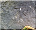
Ordnance Survey Cut Mark
This OS cut mark can be found at the lane junction with Brynheulog Street. It marks a point 320.314m above mean sea level.
Image: © Adrian Dust
Taken: 18 Aug 2018
0.04 miles
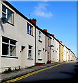
2
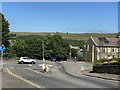
Mini roundabout
Mini roundabout at Fairview, Ebbw Vale.
Image: © Alan Hughes
Taken: 15 Jul 2021
0.05 miles
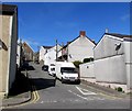
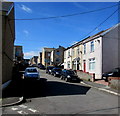
3

Up a side road from Harcourt Street, Ebbw Vale
Between numbers 65 and 67 Harcourt Street, an unnamed side road ascends towards Mount Pleasant Road.
Image: © Jaggery
Taken: 27 May 2015
0.06 miles
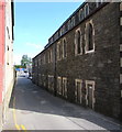
4
Bridge Street, Ebbw Vale
Ascending from Harcourt Street towards Mount Pleasant Presbyterian Church, Mount Pleasant Road.
Image: © Jaggery
Taken: 27 May 2015
0.07 miles
5
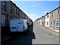
South along Harcourt Street, Ebbw Vale
From the Valley Road end.
Image: © Jaggery
Taken: 27 May 2015
0.10 miles
6
West side of Harcourt Street, Ebbw Vale
From the Tredegar Road end, looking north.
Image: © Jaggery
Taken: 27 May 2015
0.11 miles
7

Valley Road, Ebbw Vale
From the corner of Harcourt Street.
Image: © Jaggery
Taken: 27 May 2015
0.12 miles
8
Hughes Avenue, Ebbw Vale
Looking towards Mount Pleasant Road from the corner of Valley Road.
Image: © Jaggery
Taken: 27 May 2015
0.12 miles
9
Lane towards the Hughes Forrest yard in Ebbw Vale
Builders merchants premises in Harrison's Yard, viewed from the corner of Tredegar Road.
The western edge of All Saints RC Church http://www.geograph.org.uk/photo/4495325 is on the right.
Image: © Jaggery
Taken: 27 May 2015
0.13 miles
10
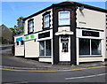
Vicky's, Ebbw Vale
Beauty and body piercing parlour on the corner of Tredegar Road and Harcourt Street.
Image: © Jaggery
Taken: 27 May 2015
0.13 miles