IMAGES TAKEN NEAR TO
Carn Y Cefn, NP23 6FL
Introduction
This page details the photographs taken nearby to Carn Y Cefn, NP23 6FL by members of the Geograph project.
The Geograph project started in 2005 with the aim of publishing, organising and preserving representative images for every square kilometre of Great Britain, Ireland and the Isle of Man.

There are currently over 7.5m images from over14,400 individuals and you can help contribute to the project by visiting https://www.geograph.org.uk
Image Map
Images are licensed for reuse under creativecommons.org/licenses/by-sa/2.0
Notes
- Clicking on the map will re-center to the selected point.
- The higher the marker number, the further away the image location is from the centre of the postcode.
Image Listing (5 Images Found)
Images are licensed for reuse under creativecommons.org/licenses/by-sa/2.0
Image
Details
Distance
1
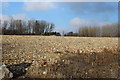
Remains of Ebbw Vale Campus of Coleg Gwent
This field of, possibly picturesque, pulverised rubble is all that remains of the college of further education demolished a few years ago. The new campus is a mile or so further down the valley.
Image: © M J Roscoe
Taken: 20 Dec 2016
0.04 miles
4
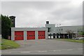
Ebbw Vale Fire Station
Ebbw Vale Fire Station, Cemetery Road, Ebbw Vale is part of the South Wales Fire & Rescue Service
Image: © Kevin Hale
Taken: 4 Jun 2007
0.23 miles
5
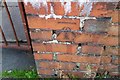
Ordnance Survey Cut Mark
This OS cut mark can be found on the gatepost of No119 Emlyn Avenue. It marks a point 315.261m above mean sea level.
Image: © Adrian Dust
Taken: 4 Oct 2018
0.24 miles