IMAGES TAKEN NEAR TO
Libanus Road, EBBW VALE, NP23 6EJ
Introduction
This page details the photographs taken nearby to Libanus Road, NP23 6EJ by members of the Geograph project.
The Geograph project started in 2005 with the aim of publishing, organising and preserving representative images for every square kilometre of Great Britain, Ireland and the Isle of Man.

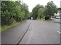
There are currently over 7.5m images from over14,400 individuals and you can help contribute to the project by visiting https://www.geograph.org.uk
Image Map
Images are licensed for reuse under creativecommons.org/licenses/by-sa/2.0
Notes
- Clicking on the map will re-center to the selected point.
- The higher the marker number, the further away the image location is from the centre of the postcode.
Image Listing (155 Images Found)
Images are licensed for reuse under creativecommons.org/licenses/by-sa/2.0
Image
Details
Distance
1
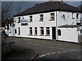
The Bridgend Pub, Ebbw Vale
Appears to be closed at the present time.
Image: © bracaragh
Taken: 22 Mar 2008
0.01 miles
2
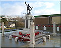
Ebbw Vale War Memorial
Viewed from Libanus Road. The War Memorial is inside a fenced-off area between the northern ends of Libanus Road and Steel Works Road.
Image: © Jaggery
Taken: 17 Dec 2011
0.01 miles
3
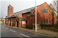
Derelict former St John the Baptist Church, Ebbw Vale
The abandoned Libanus Road church dates from 1903. There are no longer any identifying name boards remaining. Many of the windows are broken.
Image: © Jaggery
Taken: 17 Dec 2011
0.01 miles
4
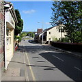
North along Libanus Road, Ebbw Vale
From the corner of Beulah Place looking past Suzanne's hair salon http://www.geograph.org.uk/photo/4495589 on the left.
Image: © Jaggery
Taken: 27 May 2015
0.01 miles
5
Ebbw Vale Low Level railway station (site), Blaenau Gwent
Opened in 1859 by the Monmouthshire Railway & Canal Company, later part of the Great Western Railway, as the terminus of the line from Newport (Gwent), this station replaced an earlier 1852 terminus some 600m south of here. In turn, this station closed in 1962. The line was later turned into a road and raised slightly. The single platform ran roughly along the left hand carriageway of the road and the main building was where the trees to the left now are.
View south towards the current Ebbw Vale Town station, beyond the tunnel, and Newport, Cardiff etc.
Image: © Nigel Thompson
Taken: 14 Aug 2015
0.02 miles
6
Geoff Rees Fitness Centre, Ebbw Vale
Located in Wesleyan Row, viewed across Steel Works Road.
Image: © Jaggery
Taken: 10 Sep 2013
0.03 miles
7
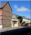
Suzanne's hair salon in Ebbw Vale
In Treve Cottage, Libanus Road.
Image: © Jaggery
Taken: 27 May 2015
0.03 miles
8
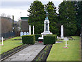
War Memorial - Ebbw Vale
The Memorial stands at the junction between Libanus Road and Steel Works Road.
Image: © Tony Bailey
Taken: 21 Nov 2007
0.04 miles
9
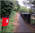
Dog waste bin alongside a riverside path, Ebbw Vale
The path is above the Ebbw River near the Bridge bar & restaurant. http://www.geograph.org.uk/photo/5533082
Image: © Jaggery
Taken: 10 Sep 2017
0.04 miles
10

Ebbw River enters a culvert, Ebbw Vale
Here about 2km from its source, the Ebbw flows into a culvert below Station Approach.
Image: © Jaggery
Taken: 10 Sep 2017
0.04 miles