IMAGES TAKEN NEAR TO
Penybryn Terrace, EBBW VALE, NP23 6DA
Introduction
This page details the photographs taken nearby to Penybryn Terrace, NP23 6DA by members of the Geograph project.
The Geograph project started in 2005 with the aim of publishing, organising and preserving representative images for every square kilometre of Great Britain, Ireland and the Isle of Man.

There are currently over 7.5m images from over14,400 individuals and you can help contribute to the project by visiting https://www.geograph.org.uk
Image Map (Loading...)


Getting Data...Please wait
Leaflet Map data © OpenStreetMap
Images are licensed for reuse under creativecommons.org/licenses/by-sa/2.0
Notes
- Clicking on the map will re-center to the selected point.
- The higher the marker number, the further away the image location is from the centre of the postcode.
Image Listing (28 Images Found)
Images are licensed for reuse under creativecommons.org/licenses/by-sa/2.0
Image
Details
Distance
1
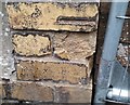
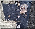
Ordnance Survey Cut Mark
This damaged OS cut mark can be found on the ruined chapel on Institution Terrace. It marks a point 335.984m above mean sea level.
Image: © Adrian Dust
Taken: 18 Aug 2018
0.05 miles
3
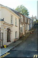
Mount Street, Ebbw Vale
Houses on the south side of Mount Street, a steep side street viewed from Church Street.
Image: © Jaggery
Taken: 29 Sep 2011
0.10 miles
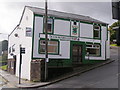
4
1st Ebbw Vale (Penuel) Scout Group HQ, Ebbw Vale
Formed in 1910, the 1st Ebbw Vale Scout Group had its headquarters in various locations in Ebbw Vale, before buying and converting this building, the former Penuel chapel located on the corner of Church Street and Mount Street. When the building was officially opened as their new HQ in late 1989, the group added (Penuel) to its name.
Image: © Jaggery
Taken: 29 Sep 2011
0.10 miles
5
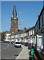
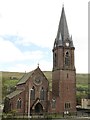
Grade II listed Christ Church, Ebbw Vale
A view along Church Crescent towards the spire of Christ Church. The church was opened for religious services in December 1861 and consecrated in August 1869. Grade II listed in October 1999.
Image: © Jaggery
Taken: 29 Sep 2011
0.10 miles
6
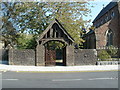
Lych gate, Christ Church, Ebbw Vale
Located at the NW edge of the Grade II listed church. http://www.geograph.org.uk/photo/2625486 The lych gate was formerly used to shelter a coffin until the clergyman's arrival for the burial, or pre-burial service.
Image: © Jaggery
Taken: 29 Sep 2011
0.10 miles
7
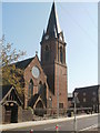
Ebbw Vale : Christ Church viewed from the north
The steeple clocks of both faces in view are showing the correct time. The Grade II listed church http://www.geograph.org.uk/photo/2625486 viewed from the southern end of Church Street.
Image: © Jaggery
Taken: 29 Sep 2011
0.10 miles
8
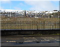
Ebbw Vale : Christ Church and snowy hills
A view from Steel Works Road towards Christ Church. http://www.geograph.org.uk/photo/2625533
This mid-December 2011 view was taken during a coldish spell when snow remained on hills in the area whereas the main hazard in much of Ebbw Vale was patchy ice on pavements and roads.
Image: © Jaggery
Taken: 17 Dec 2011
0.10 miles
10
Ordnance Survey Cut Mark
This OS cut mark can be found on No78 Drysiog Street. It marks a point 347.036m above mean sea level.
Image: © Adrian Dust
Taken: 18 Aug 2018
0.11 miles