IMAGES TAKEN NEAR TO
Bethcar Street, EBBW VALE, NP23 6BB
Introduction
This page details the photographs taken nearby to Bethcar Street, NP23 6BB by members of the Geograph project.
The Geograph project started in 2005 with the aim of publishing, organising and preserving representative images for every square kilometre of Great Britain, Ireland and the Isle of Man.

There are currently over 7.5m images from over14,400 individuals and you can help contribute to the project by visiting https://www.geograph.org.uk
Image Map
Images are licensed for reuse under creativecommons.org/licenses/by-sa/2.0
Notes
- Clicking on the map will re-center to the selected point.
- The higher the marker number, the further away the image location is from the centre of the postcode.
Image Listing (91 Images Found)
Images are licensed for reuse under creativecommons.org/licenses/by-sa/2.0
Image
Details
Distance
1
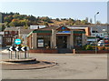
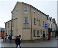
Former Pets Ahead premises, Ebbw Vale
A chartered surveyors' notice in the window of Unit 9, The Walk Retail Centre shows RETAIL UNIT TO LET.
Image: © Jaggery
Taken: 29 Sep 2011
0.03 miles
2
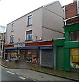
The Plug, Ebbw Vale
Electrical and fancy goods shop, 77 Bethcar Street.
Image: © Jaggery
Taken: 17 Dec 2011
0.04 miles
3
Market Tavern, Ebbw Vale
Pub on the corner of Bethcar Street and The Walk. A notice on the wall states that there is live music every Friday and Saturday, with free admission.
Image: © Jaggery
Taken: 29 Sep 2011
0.04 miles
4
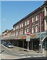
Covered walkway, Bethcar Street, Ebbw Vale
Viewed from Armoury Terrace. A long sloping roof projects from shops on the east side of the street.
Image: © Jaggery
Taken: 29 Sep 2011
0.04 miles
5
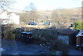
Towards The Walk, Ebbw Vale
Looking across Holland Street towards McDonald's on the southern side of The Walk; viewed from the north east corner of the car park on Armoury Terrace. The white building, left, is on The Walk, and the former industrial land behind seems to be in need of regeneration in this once thriving steel town.
Image: © M J Roscoe
Taken: 11 Jan 2018
0.04 miles
6
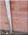
Ordnance Survey Cut Mark
This OS cut mark can be found on the old PC, west side of Armoury Terrace. It marks a point 305.565m above mean sea level.
Image: © Adrian Dust
Taken: 18 Aug 2018
0.06 miles
7
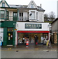
Sweets & Things, Ebbw Vale
Sweet shop at 61 Bethcar Street, next door to the post office. http://www.geograph.org.uk/photo/1830249 61 Bethcar Street has had various recent uses, including as a political campaign office and as Forget Me Not florists.
Image: © Jaggery
Taken: 17 Dec 2011
0.08 miles
8
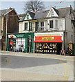
Ebbw Vale Post Office
Located in central Ebbw Vale at 63 Bethcar Street.
The adjoining premises are in use as a campaign office for the 2010 General Election. The photo was taken eight days before polling day.
Image: © Jaggery
Taken: 28 Apr 2010
0.08 miles
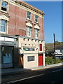
9
Ebbw Vale Conservative Club
Located at 40 Bethcar Street.
Image: © Jaggery
Taken: 17 Dec 2011
0.08 miles
10
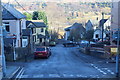
Cross roads, Alexandra Street, Ebbw Vale
Unnamed minor road crossing the end of Alexandra Street Image, right foreground, and running downhill to cross Holland Street to become a cul-de-sac, centre.
Image: © M J Roscoe
Taken: 11 Jan 2018
0.09 miles