IMAGES TAKEN NEAR TO
Clos Pen Y Cae, EBBW VALE, NP23 6AW
Introduction
This page details the photographs taken nearby to Clos Pen Y Cae, NP23 6AW by members of the Geograph project.
The Geograph project started in 2005 with the aim of publishing, organising and preserving representative images for every square kilometre of Great Britain, Ireland and the Isle of Man.

There are currently over 7.5m images from over14,400 individuals and you can help contribute to the project by visiting https://www.geograph.org.uk
Image Map
Images are licensed for reuse under creativecommons.org/licenses/by-sa/2.0
Notes
- Clicking on the map will re-center to the selected point.
- The higher the marker number, the further away the image location is from the centre of the postcode.
Image Listing (151 Images Found)
Images are licensed for reuse under creativecommons.org/licenses/by-sa/2.0
Image
Details
Distance
2
Dairy Farmers of Britain, Ebbw Vale
Located in Cwm Draw Industrial Estate.
Image: © Jaggery
Taken: 27 May 2015
0.04 miles
3
Preparations Strouds Garage, Ebbw Vale
Vehicle body repairs & styling specialists in Cwm Draw Industrial Estate.
Image: © Jaggery
Taken: 27 May 2015
0.05 miles
4
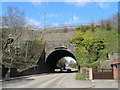
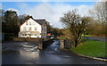
Newtown Bridge, Steelworks Road, Ebbw Vale
Every day motorists and pedestrians pass under this immense structure little realising its importance. Dating back to 1790 the bridge originally carried a horse powered railway to carry iron ore to the blast furnaces. This view shows the 1813 arch from the south. The whole structure contains three arches - 2 for roads and one for the River Ebbw and a pedestrian tunnel. It is a Grade II listed structure with Cadw.
Image: © Colin Cheesman
Taken: 3 Apr 2008
0.05 miles
5
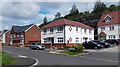
Clos Pen y Cae, Ebbw Vale
Recently-built houses near the site of demolished steelworks.
Image: © Jaggery
Taken: 10 Sep 2013
0.05 miles
6
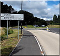
Left turn for Blaenau Gwent Learning Zone, Ebbw Vale
Viewed along Steel Works Road. The left turn leads here. http://www.geograph.org.uk/photo/3977102
Image: © Jaggery
Taken: 10 Sep 2013
0.06 miles
7
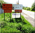
Nameboards at the entrance to Cwm Draw Industrial Estate, Ebbw Vale
Near the corner of Louvain Terrace and Providence Baptist Church. http://www.geograph.org.uk/photo/4496099
Image: © Jaggery
Taken: 27 May 2015
0.07 miles
8
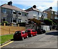
Louvain Terrace semis in Ebbw Vale
Semi-detached houses near Providence Baptist Church.
Image: © Jaggery
Taken: 27 May 2015
0.07 miles
9
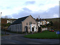
Providence Baptist Church - Ebbw Vale
Church built in 1850, still in use and well cared for.
Image: © Tony Bailey
Taken: 21 Nov 2007
0.08 miles
10
The Croft, Steel Works Road, Ebbw Vale
The Croft, near the northern end of Steel Works Road, contains ten flats.
Image: © Jaggery
Taken: 17 Dec 2011
0.08 miles