IMAGES TAKEN NEAR TO
Hill Street, EBBW VALE, NP23 6AE
Introduction
This page details the photographs taken nearby to Hill Street, NP23 6AE by members of the Geograph project.
The Geograph project started in 2005 with the aim of publishing, organising and preserving representative images for every square kilometre of Great Britain, Ireland and the Isle of Man.

There are currently over 7.5m images from over14,400 individuals and you can help contribute to the project by visiting https://www.geograph.org.uk
Image Map
Images are licensed for reuse under creativecommons.org/licenses/by-sa/2.0
Notes
- Clicking on the map will re-center to the selected point.
- The higher the marker number, the further away the image location is from the centre of the postcode.
Image Listing (67 Images Found)
Images are licensed for reuse under creativecommons.org/licenses/by-sa/2.0
Image
Details
Distance
1
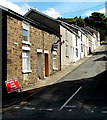
North side of Hill Street, Ebbw Vale
Hill Street is the most northerly of a group of streets on the east side of the B4486 Steel Works Road.
Image: © Jaggery
Taken: 10 Sep 2013
0.02 miles
2
Road south into Tyllwyn, Ebbw Vale
Looking towards a car parked near the corner of Hill Street. http://www.geograph.org.uk/photo/3975478
Image: © Jaggery
Taken: 27 May 2015
0.02 miles
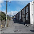
3
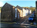
Hill Street, Ty Llwyn, Ebbw Vale
Hill Street climbs away from West View Terrace, Steel Works Road.
Image: © Jaggery
Taken: 17 Dec 2011
0.04 miles
4
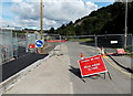
B4486 Steel Works Road closed, Ebbw Vale
Viewed in early September 2013. A Stagecoach (bus company) notice on a post nearby states that the road has been closed since July 22nd 2013. Walkers are directed to the left, towards a fenced-off path through a road construction site.
Image: © Jaggery
Taken: 10 Sep 2013
0.04 miles
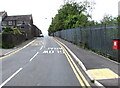
5
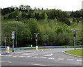
Junction near Tyllwyn, Ebbw Vale
There is a 30mph speed limit and 7.5 tonnes vehicle weight limit
(except for access) on the road to the Tyllwyn area of Ebbw Vale.
Image: © Jaggery
Taken: 17 May 2015
0.05 miles
6
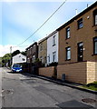
Oakfield Terrace, Ebbw Vale
Looking north along one of a group of streets on the east side of the B4486 Steel Works Road.
Image: © Jaggery
Taken: 10 Sep 2013
0.05 miles
7
Greenfield Terrace, Ebbw Vale
Viewed from near the NW edge of the former Tyllwyn School. http://www.geograph.org.uk/photo/3666351
Image: © Jaggery
Taken: 10 Sep 2013
0.05 miles
8
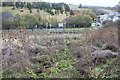
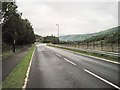
Steel Works Road junction, Ebbw Vale
In the centre of the picture the B4486 meets the A4281; both are designated as Steel Works Road, but the A section has been improved and extended south of the junction. In the centre foreground is a small overgrown stream in the wildlife area of Central Valley. Beyond the road is an old tip.
Image: © M J Roscoe
Taken: 15 Nov 2016
0.06 miles
9
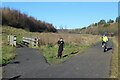
Cycle path, Central Valley LNR, Ebbw Vale
Cycle and pedestrian path, tarmacked during the summer, on the site of the former steelworks
Image: © M J Roscoe
Taken: 26 Nov 2020
0.06 miles
10
Tyllwyn Halt railway station (site), Blaenau Gwent
Opened in 1943 on the Great Western Railway's line from Newport (Gwent) to Ebbw Vale Low Level, this station closed in 1962.
View south towards Ebbw Vale Parkway and Newport, Cardiff etc. The current line runs to the right of the fence. The exact location is hard to pinpoint due to complete redevelopment of the area but is believed to have been roughly between the lamp post in the centre of the image and the bend in the road.
Image: © Nigel Thompson
Taken: 14 Aug 2015
0.06 miles