IMAGES TAKEN NEAR TO
West View Terrace, EBBW VALE, NP23 6AB
Introduction
This page details the photographs taken nearby to West View Terrace, NP23 6AB by members of the Geograph project.
The Geograph project started in 2005 with the aim of publishing, organising and preserving representative images for every square kilometre of Great Britain, Ireland and the Isle of Man.

There are currently over 7.5m images from over14,400 individuals and you can help contribute to the project by visiting https://www.geograph.org.uk
Image Map
Images are licensed for reuse under creativecommons.org/licenses/by-sa/2.0
Notes
- Clicking on the map will re-center to the selected point.
- The higher the marker number, the further away the image location is from the centre of the postcode.
Image Listing (66 Images Found)
Images are licensed for reuse under creativecommons.org/licenses/by-sa/2.0
Image
Details
Distance
1
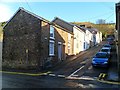
Hill Street, Ty Llwyn, Ebbw Vale
Hill Street climbs away from West View Terrace, Steel Works Road.
Image: © Jaggery
Taken: 17 Dec 2011
0.01 miles
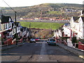
2
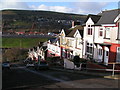
Greenfield Terrace, Ebbw Vale
Viewed from near the NW edge of the former Tyllwyn School. http://www.geograph.org.uk/photo/3666351
Image: © Jaggery
Taken: 10 Sep 2013
0.02 miles
4
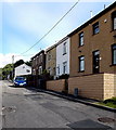
Oakfield Terrace, Ebbw Vale
Looking north along one of a group of streets on the east side of the B4486 Steel Works Road.
Image: © Jaggery
Taken: 10 Sep 2013
0.03 miles
5
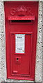
King George V postbox in a Tyllwyn wall, Ebbw Vale
Located here. http://www.geograph.org.uk/photo/4514917
Image: © Jaggery
Taken: 27 May 2015
0.03 miles
7
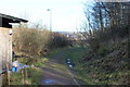
Environmental Resource Centre grounds, Ebbw Vale
Part of the northern section of the grounds of Gwent Wildlife Trust's centre. The Centre's office is just visible on the right. The partly buried railway line on the roadway was part of the former steelworks' rail network. The street light illuminates the new A4281 which cuts through part of the original grounds of the centre.
Image: © M J Roscoe
Taken: 2 Feb 2016
0.04 miles
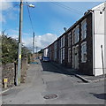
8
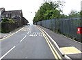
Road south into Tyllwyn, Ebbw Vale
Looking towards a car parked near the corner of Hill Street. http://www.geograph.org.uk/photo/3975478
Image: © Jaggery
Taken: 27 May 2015
0.04 miles
9
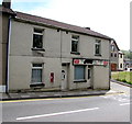
Former Tyllwyn General Stores and Post Office, Ebbw Vale
Long derelict corner premises viewed in late May 2015. The wall postbox http://www.geograph.org.uk/photo/4514925 remains in use.
Image: © Jaggery
Taken: 27 May 2015
0.04 miles
10
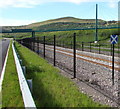
St Andrew's Cross railway sign, Ebbw Vale
I haven't yet discovered what this sign alongside the railway between Ebbw Vale Town station
and Ebbw Vale Parkway station signifies. It resembles the Saltire, the national flag of Scotland.
As this is South Wales, hundreds of kilometres from Scotland, the resemblance appears coincidental.
Image: © Jaggery
Taken: 17 May 2015
0.04 miles