IMAGES TAKEN NEAR TO
Clos Lon Fawr, EBBW VALE, NP23 5TB
Introduction
This page details the photographs taken nearby to Clos Lon Fawr, NP23 5TB by members of the Geograph project.
The Geograph project started in 2005 with the aim of publishing, organising and preserving representative images for every square kilometre of Great Britain, Ireland and the Isle of Man.

There are currently over 7.5m images from over14,400 individuals and you can help contribute to the project by visiting https://www.geograph.org.uk
Image Map
Images are licensed for reuse under creativecommons.org/licenses/by-sa/2.0
Notes
- Clicking on the map will re-center to the selected point.
- The higher the marker number, the further away the image location is from the centre of the postcode.
Image Listing (40 Images Found)
Images are licensed for reuse under creativecommons.org/licenses/by-sa/2.0
Image
Details
Distance
1
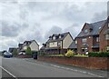
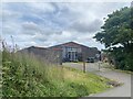
Clos Lon Fawr
New housing in Beaufort Hill.
Image: © Alan Hughes
Taken: 13 Aug 2024
0.00 miles
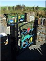
3
Vehicle barrier, Big Lane / Lon Fawr, Brynmawr
Image: © John Lord
Taken: 11 Feb 2012
0.04 miles
4
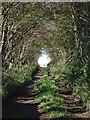
Beaufort Hill Woodland, Lane to N.E.Entrance
Image: © Kev Griffin
Taken: 5 Oct 2007
0.05 miles
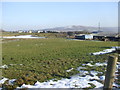
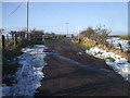
8
Big Lane, Beaufort
Big Lane heads away from Beaufort Hill towards Farmers Lane.
Image: © Jaggery
Taken: 28 Apr 2010
0.08 miles
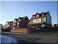
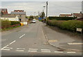
9
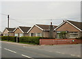
Bungalows, Beaufort
Bungalows on the north side of the A4047, near the corner of Big Lane. http://www.geograph.org.uk/photo/1829975
Image: © Jaggery
Taken: 28 Apr 2010
0.08 miles
10
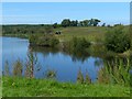
The eastern end of Lower Boat Pond
The view from the small car park in Little Lane.
Image: © Robin Drayton
Taken: 5 Sep 2013
0.08 miles