IMAGES TAKEN NEAR TO
Rassau Road, EBBW VALE, NP23 5SH
Introduction
This page details the photographs taken nearby to Rassau Road, NP23 5SH by members of the Geograph project.
The Geograph project started in 2005 with the aim of publishing, organising and preserving representative images for every square kilometre of Great Britain, Ireland and the Isle of Man.

There are currently over 7.5m images from over14,400 individuals and you can help contribute to the project by visiting https://www.geograph.org.uk
Image Map
Images are licensed for reuse under creativecommons.org/licenses/by-sa/2.0
Notes
- Clicking on the map will re-center to the selected point.
- The higher the marker number, the further away the image location is from the centre of the postcode.
Image Listing (49 Images Found)
Images are licensed for reuse under creativecommons.org/licenses/by-sa/2.0
Image
Details
Distance
1
Rassau - Cendl Crescent
Taken from School Road, Rassau.
Image: © Tony Bailey
Taken: 30 Apr 2006
0.02 miles
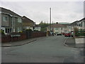
2
Rassau Road houses, Rassau
This is an upland location in the north of Blaenau Gwent.
Rassau Road here is about 335 metres (c1,100 ft) above sea level.
Image: © Jaggery
Taken: 10 Sep 2013
0.03 miles
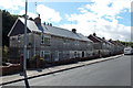
3

Cendl Crescent, Rassau
Viewed across School Road. Cendl is the Welsh name of the adjacent village known in English as Beaufort.
Image: © Jaggery
Taken: 16 May 2014
0.08 miles
4
Rassau - Old School
The Old Primary School, now an Educational resource Centre. Taken from School Road, Rassau.
Image: © Tony Bailey
Taken: 30 Apr 2006
0.08 miles
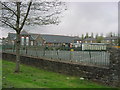
5

Rassau Resource Centre
Adult education centre viewed from Bryn-yr-Ysgol, Rassau.
Image: © Jaggery
Taken: 16 May 2014
0.10 miles
6
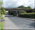
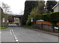
A4046 bridge over Rassau Road, Rassau
Rassau Road passes under the bridge carrying the A4046 south
from its junction with the A465 Heads of the Valleys Road.
Image: © Jaggery
Taken: 10 Sep 2013
0.10 miles
7
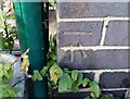
Ordnance Survey Cut Mark
This OS cut mark can be found on the SE angle of the old school. It marks a point 340.861m above mean sea level.
Image: © Adrian Dust
Taken: 4 Oct 2018
0.10 miles
8
School Road passes under the A4046, Rassau
Signs show a 7.5 tonnes weight limit ahead (except for access).
Image: © Jaggery
Taken: 16 May 2014
0.11 miles
9
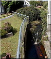
Nant Melyn, Rassau
The brook Nant Melyn tumbles down a tiny waterfall at the edge of Rassau Road.
Nant Melyn flows into Rasa Brook, a tributary of the Ebbw River.
Image: © Jaggery
Taken: 10 Sep 2013
0.12 miles
10
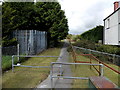
Path from Rassau Road to Waun Fawr, Rassau
The path is alongside a brook on the left, Nant Melyn. http://www.geograph.org.uk/photo/3646872
Image: © Jaggery
Taken: 10 Sep 2013
0.12 miles