IMAGES TAKEN NEAR TO
Maple Way, EBBW VALE, NP23 5SA
Introduction
This page details the photographs taken nearby to Maple Way, NP23 5SA by members of the Geograph project.
The Geograph project started in 2005 with the aim of publishing, organising and preserving representative images for every square kilometre of Great Britain, Ireland and the Isle of Man.

There are currently over 7.5m images from over14,400 individuals and you can help contribute to the project by visiting https://www.geograph.org.uk
Image Map
Images are licensed for reuse under creativecommons.org/licenses/by-sa/2.0
Notes
- Clicking on the map will re-center to the selected point.
- The higher the marker number, the further away the image location is from the centre of the postcode.
Image Listing (18 Images Found)
Images are licensed for reuse under creativecommons.org/licenses/by-sa/2.0
Image
Details
Distance
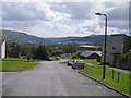
1
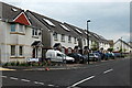
Clydach Avenue, Rassau
Semi-detached houses at the western end of Clydach Avenue, opposite Rassau Old Age Pensioners Hall.
Image: © Jaggery
Taken: 16 May 2014
0.17 miles
2
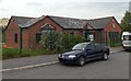
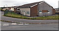
Rassau Youth Centre
Viewed across Summerfield Road, Rassau. The youth centre opened in April 2009.
Image: © Jaggery
Taken: 16 May 2014
0.18 miles
4
Rassau Old Age Pensioners Hall
Located in Clydach Avenue.
Image: © Jaggery
Taken: 16 May 2014
0.20 miles
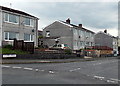
5
Pen y Bryn houses, Rassau
Viewed from Honeyfield Road.
Image: © Jaggery
Taken: 16 May 2014
0.20 miles
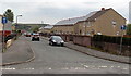
6
Rowan Way, Rassau
Viewed across Honeyfield Road.
Image: © Jaggery
Taken: 16 May 2014
0.21 miles
7

Scaffolding on Avon Court flats in Rassau
Viewed from Honeyfield Road. It looks like roofing work is being undertaken.
Image: © Jaggery
Taken: 16 May 2014
0.21 miles
8
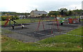
Children's playground in Rassau
Viewed from Clydach Avenue.
Image: © Jaggery
Taken: 16 May 2014
0.21 miles
9
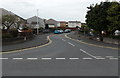
Glyndwr Road, Rassau
On the east side of Honeyfield Road.
Image: © Jaggery
Taken: 16 May 2014
0.21 miles