IMAGES TAKEN NEAR TO
Church Crescent, EBBW VALE, NP23 5PE
Introduction
This page details the photographs taken nearby to Church Crescent, NP23 5PE by members of the Geograph project.
The Geograph project started in 2005 with the aim of publishing, organising and preserving representative images for every square kilometre of Great Britain, Ireland and the Isle of Man.

There are currently over 7.5m images from over14,400 individuals and you can help contribute to the project by visiting https://www.geograph.org.uk
Image Map
Images are licensed for reuse under creativecommons.org/licenses/by-sa/2.0
Notes
- Clicking on the map will re-center to the selected point.
- The higher the marker number, the further away the image location is from the centre of the postcode.
Image Listing (78 Images Found)
Images are licensed for reuse under creativecommons.org/licenses/by-sa/2.0
Image
Details
Distance
1
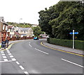
Cycle route signpost, Beaufort
Viewed across Church Crescent opposite Price's store. http://www.geograph.org.uk/photo/3647511
One signpost arm points left towards Brynmawr and Abergavenny.
The other arm points right towards Ebbw Vale and Merthyr Tydfil.
Image: © Jaggery
Taken: 10 Sep 2013
0.02 miles
2
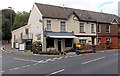
Price's general stores and off licence, Beaufort
Located at 1 Church Crescent.
Image: © Jaggery
Taken: 10 Sep 2013
0.02 miles
3
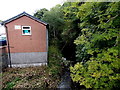
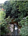
Ebbw River flows towards the A4047, Beaufort
The river here marks the boundary between Ebbw Vale on the left and Beaufort on the right.
Slightly misplaced, the Beaufort boundary sign http://www.geograph.org.uk/photo/3647408 is nearby.
Image: © Jaggery
Taken: 10 Sep 2013
0.03 miles
4
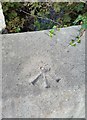
Ordnance Survey Rivet
This OS rivet can be found on the north parapet of the bridge on Beaufort Rise. It marks a point 324.812m above mean sea level.
Image: © Adrian Dust
Taken: 4 Oct 2018
0.04 miles
5
Ebbw River flows away from the A4047, Beaufort
The river here marks the boundary between Ebbw Vale on the right and Beaufort on the left.
Slightly misplaced, the Beaufort boundary sign http://www.geograph.org.uk/photo/3647408 is nearby.
Image: © Jaggery
Taken: 10 Sep 2013
0.04 miles
6
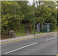
Western boundary of Beaufort
Viewed across the A4047. Beaufort (Cendl in Welsh) is a village at the northern edge of the county borough of Blaenau Gwent, near Ebbw Vale. The village's name recalls the time when much of the land hereabouts was owned by the Duke of Beaufort. The bridge on the left carries the road across the Ebbw River.
Image: © Jaggery
Taken: 10 Sep 2013
0.04 miles
9
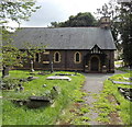
North side of St David's church, Ebbw Vale
Located on the west bank of the Ebbw River, the church is part
of the Church in Wales Rectorial Benefice of the Upper Ebbw Valleys.
Image: © Jaggery
Taken: 10 Sep 2013
0.05 miles
10
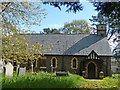
St David's Church, Beufort
The north side of the church.
Situated in the Church in Wales Rectorial Benefice of the Upper Ebbw Valleys.
Baptisms are recorded from 1843.
Image: © Robin Drayton
Taken: 24 Apr 2014
0.05 miles