IMAGES TAKEN NEAR TO
Badminton Grove, EBBW VALE, NP23 5NA
Introduction
This page details the photographs taken nearby to Badminton Grove, NP23 5NA by members of the Geograph project.
The Geograph project started in 2005 with the aim of publishing, organising and preserving representative images for every square kilometre of Great Britain, Ireland and the Isle of Man.

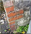
There are currently over 7.5m images from over14,400 individuals and you can help contribute to the project by visiting https://www.geograph.org.uk
Image Map
Images are licensed for reuse under creativecommons.org/licenses/by-sa/2.0
Notes
- Clicking on the map will re-center to the selected point.
- The higher the marker number, the further away the image location is from the centre of the postcode.
Image Listing (27 Images Found)
Images are licensed for reuse under creativecommons.org/licenses/by-sa/2.0
Image
Details
Distance
1
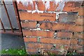
Ordnance Survey Cut Mark
This OS cut mark can be found on the gatepost of No119 Emlyn Avenue. It marks a point 315.261m above mean sea level.
Image: © Adrian Dust
Taken: 4 Oct 2018
0.11 miles
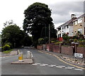
2
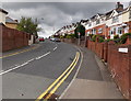
Fitzroy Avenue, Ebbw Vale
Looking towards the Glyncoed area of Ebbw Vale.
Image: © Jaggery
Taken: 10 Sep 2013
0.14 miles
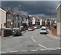
3
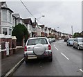
Badminton Grove cars and houses, Ebbw Vale
Badminton Grove ascends from Beaufort Road into the Glyncoed area of Ebbw Vale.
Image: © Jaggery
Taken: 10 Sep 2017
0.14 miles
4
Clos Bronwydd, Ebbw Vale
Viewed across Beaufort Road.
The triangular sign on the left shows that there are speed humps in the road for 170 yards.
Image: © Jaggery
Taken: 10 Sep 2013
0.14 miles
5
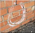
Ordnance Survey Cut Mark
This OS cut mark can be found on the wall SW side of Allotment Road. It marks a point 317.788m above mean sea level.
Image: © Adrian Dust
Taken: 4 Oct 2018
0.17 miles
6
Ordnance Survey Cut Mark
This OS cut mark can be found on the wall of No2 Pen Y Dre. It marks a point 320.083m above mean sea level.
Image: © Adrian Dust
Taken: 4 Oct 2018
0.17 miles
7
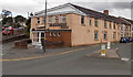
Badminton Club, Ebbw Vale
On the corner of Beaufort Terrace and Cwm Hir.
A sign pointing left towards Cwm Hir shows ¾ (mile) to Carmeltown.
Image: © Jaggery
Taken: 10 Sep 2013
0.17 miles
9
21 miles to Newport from northern Ebbw Vale
The sign showing (central) Ebbw Vale 1 (mile), Newport 21, points south along Beaufort Road.
Image: © Jaggery
Taken: 10 Sep 2013
0.18 miles
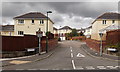
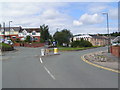
10
SE end of Badminton Grove, Ebbw Vale
Looking NW along Badminton Grove from Beaufort Road.
Image: © Jaggery
Taken: 10 Sep 2013
0.18 miles