IMAGES TAKEN NEAR TO
Adams Square, EBBW VALE, NP23 5FN
Introduction
This page details the photographs taken nearby to Adams Square, NP23 5FN by members of the Geograph project.
The Geograph project started in 2005 with the aim of publishing, organising and preserving representative images for every square kilometre of Great Britain, Ireland and the Isle of Man.

There are currently over 7.5m images from over14,400 individuals and you can help contribute to the project by visiting https://www.geograph.org.uk
Image Map
Images are licensed for reuse under creativecommons.org/licenses/by-sa/2.0
Notes
- Clicking on the map will re-center to the selected point.
- The higher the marker number, the further away the image location is from the centre of the postcode.
Image Listing (118 Images Found)
Images are licensed for reuse under creativecommons.org/licenses/by-sa/2.0
Image
Details
Distance
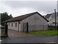
2
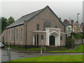
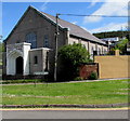
Providence Baptist Church - Ebbw Vale
Church built in 1850, still in use and well cared for.
Image: © Tony Bailey
Taken: 21 Nov 2007
0.04 miles
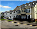
3
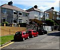
Louvain Terrace semis in Ebbw Vale
Semi-detached houses near Providence Baptist Church.
Image: © Jaggery
Taken: 27 May 2015
0.05 miles
4
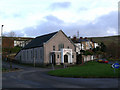
Western corner of Providence Baptist Church, Ebbw Vale
The church is at the western edge of Louvain Terrace. The years 1850 1935 on
the doorway are likely to indicate that this is the 1935 rebuild of the 1850 original.
Image: © Jaggery
Taken: 27 May 2015
0.05 miles
5
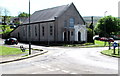
South side of Providence Baptist Church, Ebbw Vale
The years 1850 1935 on the doorway are likely to indicate that this is the 1935 rebuild of the 1850 original.
The Louvain Terrace name sign is in the foreground.
Image: © Jaggery
Taken: 27 May 2015
0.05 miles
6
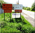
Nameboards at the entrance to Cwm Draw Industrial Estate, Ebbw Vale
Near the corner of Louvain Terrace and Providence Baptist Church. http://www.geograph.org.uk/photo/4496099
Image: © Jaggery
Taken: 27 May 2015
0.05 miles
7
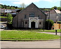
Providence Baptist Church, Ebbw Vale
The years 1850 1935 on the doorway are likely to indicate that this is the 1935 rebuild of the 1850 original. Louvain Terrace http://www.geograph.org.uk/photo/4496089 is on the right.
Image: © Jaggery
Taken: 27 May 2015
0.05 miles
8
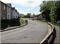
Pant-y-Fforest, Ebbw Vale
Viewed from near the Newchurch Road junction, looking SSE.
Image: © Jaggery
Taken: 27 May 2015
0.07 miles
10
Gibbons Villas, Ebbw Vale
Viewed across the street named Pant-y-Fforest. The Gibbons Villas name sign is on the right.
Image: © Jaggery
Taken: 27 May 2015
0.07 miles