IMAGES TAKEN NEAR TO
Queensway, EBBW VALE, NP23 5EJ
Introduction
This page details the photographs taken nearby to Queensway, NP23 5EJ by members of the Geograph project.
The Geograph project started in 2005 with the aim of publishing, organising and preserving representative images for every square kilometre of Great Britain, Ireland and the Isle of Man.

There are currently over 7.5m images from over14,400 individuals and you can help contribute to the project by visiting https://www.geograph.org.uk
Image Map
Images are licensed for reuse under creativecommons.org/licenses/by-sa/2.0
Notes
- Clicking on the map will re-center to the selected point.
- The higher the marker number, the further away the image location is from the centre of the postcode.
Image Listing (64 Images Found)
Images are licensed for reuse under creativecommons.org/licenses/by-sa/2.0
Image
Details
Distance
1
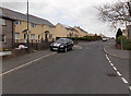
Queensway houses, Garnlydan
Viewed near Lansdowne Road.
Image: © Jaggery
Taken: 16 May 2014
0.03 miles
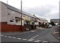
2
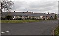
Lansdowne Road bungalows, Garnlydan
Backs of bungalows viewed from Queensway.
Image: © Jaggery
Taken: 16 May 2014
0.07 miles
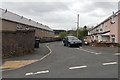
3
Commonwealth Road, Garnlydan
Looking NNW from near the corner of Queensway.
Image: © Jaggery
Taken: 16 May 2014
0.08 miles
4
Gantre Close, Garnlydan
Viewed from Queensway.
Image: © Jaggery
Taken: 16 May 2014
0.09 miles
5
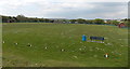
Garnlydan AFC home ground
Located on the west side of the B4560 Llangynidr Road, this is the home ground of Garnlydan AFC (Association Football Club). Viewed in May. The goalposts have been removed for the close season, so it's likely that this ground is used for cricket in the warmer months. The purpose of the traffic cones in holes is unclear - perhaps an alternative to white paint to mark the cricket pitch boundary?
Image: © Jaggery
Taken: 16 May 2014
0.09 miles
6
Heathfield Close, Garnlydan
Houses on the north side of Heathfield Close, viewed across Queensway.
Image: © Jaggery
Taken: 16 May 2014
0.09 miles
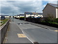
7
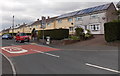
Queensway 20 zone in Garnlydan
The 30mph speed limit along the B4560 Llangynidr Road reduces to
20mph in Queensway, on the approach to Garnlydan Primary School.
Image: © Jaggery
Taken: 16 May 2014
0.09 miles
10
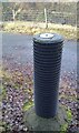
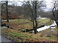
Triangulation Pillar (Not Ordnance Survey)
Found east side of road leading to Carno Reservoir.
Image: © Adrian Dust
Taken: 29 Nov 2020
0.11 miles