IMAGES TAKEN NEAR TO
Llangynidr Road, EBBW VALE, NP23 5DH
Introduction
This page details the photographs taken nearby to Llangynidr Road, NP23 5DH by members of the Geograph project.
The Geograph project started in 2005 with the aim of publishing, organising and preserving representative images for every square kilometre of Great Britain, Ireland and the Isle of Man.

There are currently over 7.5m images from over14,400 individuals and you can help contribute to the project by visiting https://www.geograph.org.uk
Image Map
Images are licensed for reuse under creativecommons.org/licenses/by-sa/2.0
Notes
- Clicking on the map will re-center to the selected point.
- The higher the marker number, the further away the image location is from the centre of the postcode.
Image Listing (57 Images Found)
Images are licensed for reuse under creativecommons.org/licenses/by-sa/2.0
Image
Details
Distance
1
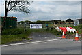
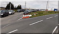
Garnlydan AFC entrance gate
The entrance from the B4560 Llangynidr Road to Garnlydan AFC's home ground. http://www.geograph.org.uk/photo/3998709
AFC = Association Football Club.
Image: © Jaggery
Taken: 16 May 2014
0.04 miles
2
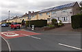
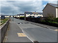
Queensway 20 zone in Garnlydan
The 30mph speed limit along the B4560 Llangynidr Road reduces to
20mph in Queensway, on the approach to Garnlydan Primary School.
Image: © Jaggery
Taken: 16 May 2014
0.04 miles
3
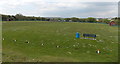
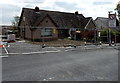
Garnlydan AFC home ground
Located on the west side of the B4560 Llangynidr Road, this is the home ground of Garnlydan AFC (Association Football Club). Viewed in May. The goalposts have been removed for the close season, so it's likely that this ground is used for cricket in the warmer months. The purpose of the traffic cones in holes is unclear - perhaps an alternative to white paint to mark the cricket pitch boundary?
Image: © Jaggery
Taken: 16 May 2014
0.07 miles
4
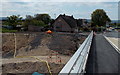
Earth bank and a condemned house in Garnlydan
The house had the misfortune to be too near the edge of the new route of the A465 being built here.
It is fenced off, probably because of the danger of collapse.
Image: © Jaggery
Taken: 16 May 2014
0.07 miles
5
Condemned bungalows in Garnlydan
The fenced-off bungalows had the misfortune to be too near the edge of the new route of the A465 being built here.
Image: © Jaggery
Taken: 16 May 2014
0.07 miles
6
Commonwealth Road, Garnlydan
Looking NNW from near the corner of Queensway.
Image: © Jaggery
Taken: 16 May 2014
0.07 miles
7
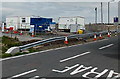
Workforce vehicles at the A465 construction site in Garnlydan
Viewed across the B4560 Llangynidr Road in May 2014.
Image: © Jaggery
Taken: 16 May 2014
0.07 miles
8
A465 construction site offices in Garnlydan
The other side of the site office buildings can be seen here http://www.geograph.org.uk/photo/4151724 at the edge of the road construction.
Image: © Jaggery
Taken: 16 May 2014
0.08 miles
9
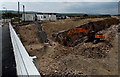
Digging a trench in Garnlydan
Work in progress in May 2014 on the new route of the A465.
Image: © Jaggery
Taken: 16 May 2014
0.10 miles
10
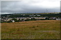
View towards Garnlydan from new viewpoint on A465
Image: © David Martin
Taken: 15 Jul 2017
0.11 miles